Sunday, November 15, 2015

The next one (weather)


Exciting weather of late! And another system is on tap.


Tuesday!


A big dip in the jet over the western part of the continent is going to push a lot of warm air ahead of it. (Meridional flow)...


Wednesday!

This is the classic Cave Swallow setup. It should be a very telling event to better understand the weather in relation to their movements  - primarily because Cave Swallows are already here! So what happens next? Do numbers continue to build? Is there an ever increasing number ready to move north, or will the "wave" (say, like spring Broad-winged Hawk migration) pass over us and leave us with less birds than before? That may be a bit of a stretch (especially because some will presumably move south again after each passing cold front) but I'm excited to see what shakes down.

Another unfolding story are these Franklin's Gulls - I noted that this last system looked pretty darn good for FRGU (in the comments, here) - but I'm not sure anyone could really predict why certain systems "pan out as expected" but others sometimes fall flat despite ideal setups. Anyhoot - with the FRGU, I am seeing a pattern in 2015 that the compounding effects of these weather events seem to be increasing FRGU sightings. Even before this big storm over the past few days, FRGU were turning up in unusual places... Then we had this monster low with far reaching winds - and huge numbers are being reported. 

Similar to my CASW questions I can't help but wonder - will the FRGU insanity continue? OR was this last system timed well enough with their final hurrah before getting ready to leave North America? Unlike CASW, will they just head south and no longer be "around" to feel the effects of the weather? Presumably they'll leave, but hopefully they take their sweet time in doing so. 


Wednesday morning again

The two lows in the above map are phasing and this system is going to rocket N fairly quickly:


Thursday am 

Not a whole lotta SW or W winds associated with the aftermath of this one...


Should be fun!


(Weds am again - hopefully condo CASW day) 


Friday, November 13, 2015

Mediocre Lakewatching at Fort Erie - 12 Nov 2015


With a gale warning in effect (45kt SW) and predicted waves up to 5m, Fort Erie was the place to be (for me). I arrived at 8am, and was entertained enough to stay in the exact same spot over 8 hours. This time I actually brought food though, which was good because it was boring as heck at times; so I entertained myself by eating... I was joined at various times by Josh Vandermeulen and Dan Riley.


The wind was strong all day, but didn't really kick it into overdrive until a trough passed overhead around 1pm. Winds gusted to nearly 50kt, and Bonaparte's Gulls finally started pushing in off Lake Erie - but there was precious little mixed in with them. Perhaps my biggest highlight was watching  the water levels rise and drop and rise again. Things were actually starting to look pretty hairy around Fort Erie and Buffalo by dusk, as several roads appeared to be closed.

Below is a screenshot of the buoy from offshore:


The "morning flight" of birds was not aided whatsoever by interesting weather, so I ended up watching the standard fare of gulls, ducks and cormorants wander in and out of the river - as well as a few feeding frenzies. Things started getting tossed around by 1pm (as noted) but there was a lack of unusual things about to keep one entertained as they were pushed in off the lake.

The list! -

Canada Goose  25
Gadwall  20
American Black Duck  25
Mallard  15
Northern Pintail  3
Redhead  6
Greater Scaup  30
Lesser Scaup  3
Surf Scoter  15
White-winged Scoter  20
Black Scoter  4
Long-tailed Duck  600
Bufflehead  2000
Common Goldeneye  85
Common Merganser  20
Red-breasted Merganser  225
Red-throated Loon  3
Common Loon  10
Horned Grebe  40
Red-necked Grebe  1
Double-crested Cormorant  400  
Red-tailed Hawk  1
Parasitic Jaeger  1  
Bonaparte's Gull  2000
Little Gull  6  
Ring-billed Gull  120
Herring Gull  25
Great Black-backed Gull  4
Peregrine Falcon  2  
American Crow  2
Black-capped Chickadee  3
Golden-crowned Kinglet  6
European Starling  20
House Sparrow  5


The skinny:

Lotsa Bufflehead
3 Red-throated Loons
1 Red-necked Grebe
1 Leucistic Milky/White Double-crested Cormorant
1 juv Parasitic Jaeger
6 adult Little Gulls
2 Peregrine Falcons


White one just right of centre


Buff City. 


Check out my ebird checklist for more commentary on numbers etc:

http://ebird.org/ebird/view/checklist/email?subID=S25808305

Still a fun day to be out there! Although I do  have a strong "went the wrong day" feeling as the winds continue....


Wall was damaged in ~5 places along the shoreline 


Tuesday, November 10, 2015

2015 BIG YEAR - October Update

October 2015

This is the tenth monthly summary of my 2015 CONDO BIG YEAR!!!


Red dot is my condo building


Red mark is the blue area defined in the first map


Click for - BIG YEAR RULES


The birds! (new species in bold)-

Canada Goose - 176
Mute Swan - 1
Trumpeter Swan - 1
Tundra Swan - 353
Gadwall - 2
American Wigeon - 275
American Black Duck - 69
Mallard - 421
Northern Shoveler - 55
Northern Pintail - 738
Green-winged Teal - 88
Redhead - 20
Greater Scaup - 295
Lesser Scaup - 50
Surf Scoter - 6070
White-winged Scoter - 7965
Black Scoter - 254
Long-tailed Duck - 20,550
Bufflehead - 152
Common Goldeneye - 417
Common Merganser - 8
Red-breasted Merganser - 307
Red-throated Loon - 12
Common Loon - 101
Horned Grebe - 2
Red-necked Grebe - 2
Double-crested Cormorant - 1160
Great Blue Heron - 3
Turkey Vulture - 1
Northern Harrier - 1
Sharp-shinned Hawk - 1
Cooper's Hawk - 1
Bald Eagle - 2
Red-tailed Hawk - 7
Black-bellied Plover - 1
Killdeer - 1
White-rumped Sandpiper - 2
Parasitic Jaeger - 1
Sabine's Gull - 1
Bonaparte's Gull - 110
Ring-billed Gull - 1210
Hering Gull - 368
Lesser Black-backed Gull - 6
Great Black-backed Gull - 36
Common Tern - 61
Rock Pigeon - 8
Mourning Dove - 85
Yellow-bellied Sapsucker - 3
Downy Woodpecker - 3
Hairy Woodpecker - 1
Northern Flicker - 3
American Kestrel - 2
Merlin - 6
Peregrine Falcon - 7
Eastern Wood-Pewee - 1
Eastern Phoebe - 1
Blue-headed Vireo - 5
Blue Jay - 15
American Crow - 3
Black-capped Chickadee - 13
White-breasted Nuthatch - 1
Brown Creeper - 34
Winter Wren - 2
Golden-crowned Kinglet - 134
Ruby-crowned Kinglet - 36
Hermit Thrush - 4American Robin - 34
European Starling - 279
Cedar Waxwing - 2
Snow Bunting - 1
Orange-crowned Warbler - 1
Magnolia Warbler - 1
Palm Warbler - 1
Yellow-rumped Warbler - 34
Black-throated Green Warbler - 1
Chipping Sparrow - 11
Dark-eyed Junco - 124
White-crowned Sparrow - 38
White-throated Sparrow - 290
Song Sparrow - 3
Northern Cardinal - 3
Red-winged Blackbird - 152
Common Grackle - 3
Brown-headed Cowbird - 4
House Finch - 35
Common Redpoll - 40
Pine Siskin - 42
American Goldfinch - 38
House Sparrow - 105

Total species - 86

Total ebird checklists - 27

Best birds of the month: Sabine's Gull... Not much really

Useless seasonal rarities: Common Redpoll, Eastern Wood-Pewee

Highlight "big year" birds: rarities aside - Orange-crowned Warbler, Winter Wren, Hermit Thrush, White-rumped Sandpiper


Total species added to the big year this month: 6

Big year total to date: 194


Target species going forwards:  pretty much rares at this point. Snow Goose, Brant, Purple Sandpiper, Cave Swallow, Gannet, Harlequin Duck, Barrow's Gold, Pacific Loon, Black-legged Kittiwake... A few sorta-not-rares available though like Greater Yellowlegs, Short-eared Owl

KM driven: 0
KM flown: 0
KM by boat: 0
KM by train: 0
KM by helicopter: 0

(1 Kilometer = 0.621371192237334 Miles)


Previous summaries: January | February | March | April | May | June July |August | September


---


Thoughts:

I was guns blazing at the start of October. 50-70kph NE winds were in the forecast for days. DAYS I tell you. And there were no good waterbirds to show for it. I eventually scored 2 White-rumped Sandpipers (new for the condo, all time list now at 209), which were a tiny part of the "event" that grounded them in southern Ontario... But instead of basking in Kittiwake goodness, it was the passerines that kept me entertained (5 passerines new for the big year, including some previously notable admissions like Blue-headed Vireo, Hermit Thrush etc). 

After the torrid pace I was adding big-year-birds in late September and early October had me thinking that 200 was maybe slightly possible. Now my last new "year bird" for the big year was on Oct 11th... Since that time, the weather and birding have been decidedly dull around the condo... It could well be a vicious cycle where I start to lose interest in looking, and therefore see even less... I may need some motivation... Motivate me!!!

As the "target species" list shows above, the only birds I can score are genuine notable species around here, with perhaps greater odds of finding rarities (Kittiwake, Harlequin, Gannet, Cave Swallow) than any of the more common species in our region. Hopefully the weather cooperates and a few more "big" checklists are in store!


Oct 1


Oct 3


Oct 15

Sunday, November 8, 2015

Another Monster on the Way (Rarity Alert)


The gales of November - in Mid November.


GFS model run showing a mega 981mb low nearing the Great Lakes

I am starting to feel like a bit of a broken record, as we are roughly lined up with the storm track (of late) with phasing late fall low's putting us in the crosshairs. Instead of breaking down the weather right away, I've decided to toot my own horn instead:

---


Decidedly NOT a Cave Swallow storm (and limited passerine potential), noted in advance. Instead there was some great lake watching and something about a rare goose in eastern Ontario. Rarity alert sucess!


---


Looked far more suitable for Cave Swallows and associated passerines, although noted that it was not a slam dunk due to the timing of the storm and some local precip/fog. Regardless, some CASW were found on Lakes Ontario and Erie  and a freakin Bronzed Cowbird appeared in upstate New York. Rarity alert success!


---


SO with my tooting out of the way, let's break this one down!


Red - a moderate Colorado low is going to move NE, and will phase with 2 to 3 weak centres of low pressure pushing in from the NW (weaker lows in orange).


Due to the rapidly evolving nature of the cyclone there will likely be limited time in the Great Lakes for Cave Swallows (potentially worse than this last event), where suitable winds may occur overnight, but too late on Wednesday and rain spoils the fun on Thursday. The GOOD NEWS for Cave Swallow aficionado's is that they're already on the doorstep, so even a limited period of decent weather could yield a few birds (that is, of course, if you subscribe to the theory that they move north in stages, not unlike spring migrants).

The map above highlights the narrow/limited and short lived corridor of precipitation free airspace overnight from Weds-Thurs. The "all it takes is one bird" theory could be applied and some vagrants could be brought north on those winds, but overall it isn't looking as good as the most recent storm...

OF COURSE - it is important to remember that these maps are MODEL RUNS, meaning they are bound to change... If the storm slows down by 12 hours suddenly we could have a day of decent S winds (and sun) before having the rain fall overnight. Worth keeping an eye on!


The part that is much easier to predict, and the part that I'm more excited for is AFTER the system peaks and we are left with the blazing "witches brew" of SW to W winds pushing in from anywhere between Kansas and North Dakota right to Lake Erie. The low is going to be very strong and right over the Great Lakes, so things will be squally and awesome at your favourite waterbird spots. 

I'm betting on the best (worst) of the weather to be during the day on Thursday, but it could be good on Friday too. It's a classic November storm!


(I'm not sure why, but I have alcid's on the Brain. Tiny western alcids. Wouldn't complain over an eastern one either) 


Monday, November 2, 2015

Moderate Cave Swallow Alert? Moderate Rarity Alert? - Weds to Friday


Wednesday!


S or SW flow into the great lakes - and it's gonna be warm! Perhaps another moderate dose of rares could reach our shores? I don't have really high hopes for anything too nutty - but warm air in the first week of November sure sounds good to me...


By Thursday the S or SW winds will be stronger and the fetch will be greater. This feels like a classic CASW setup to me... I mean, it could be better - but it's the right time of year, 20C and decent winds. I'll have my fingers crossed (and again, maybe we'll get real lucky and something else will come along). 


One issue I see with this forecast are the hints of precipitous precipitation around Lake Erie... These little bits of rain can sometimes make or break the birding - but are nearly impossible to forecast in advance. It could ground all of the austral migrants at your house, or it could block any birds from arrival at all! (CASW included)... 


Friday is a bit "up in the air" ... The big models have rain pushing in fast with fairly strong SW winds... If it holds off a bit, maybe we'll get a real dose of CASW. Maybe waterbirds will take advantage of the winds and your standard locales will be hopping.

One thing is for sure - the storm is going to "bomb" and rocket away to the NE - so even if it gets stormy, it may not last for very long...


Exit - stage left (8am Saturday)


So yeah! I don't want to get toooo excited, but 20C in November and S winds has got to bring something, right? Our general weather right now is starting to trend away from that split-jet-flow I talked about a few weeks ago - but basic climatology may be at play too (that means, things get stormy in Nov, pretty much every Nov). 

For now, I'll be keeping my eyes peeled for local birds, but perhaps making an effort on Thursday (and maaaybe Friday, but maybe not) for Cave Swallow and other goodies!  

Only way to find something neat with this weather is to get out there and look! 


(a bird I've seen on warm Nov SW winds a few times before... CASW are an indicator to me that things are happening!) 


Saturday, October 31, 2015

Meteorological Mechanisms for the arrival of Cave Swallows in the Great Lakes


With next Thursday (maybe weds or friday) looking like CAVE SWALLOW weather in the southern Great Lakes, I thought I'd throw down some of the meteorological patterns I have observed that were associated with Cave Swallow events... The models are still a bit variable, so I may wait a few days before throwing out the formal rarity alert. (But heads up - Tue-Wed-Thur-Fri-Sat are looking good for various reasons).

I'll also preface and say that I have NOT carefully observed CASW patterns on the east coast. If you have any additional thoughts or observations - leave them in the comments! (or email me etc)

Let's get to it!


To begin - I have a rough theory that CASW do not behave as other vagrants do. They seem (to me) to be intentionally migrating north over a period of several days to weeks, potentially even waiting out poor weather before making the next jump north. A similar behaviour would be the spring migration of Broad-winged Hawks - where you need good weather over a period of several days (to weeks) to bring the birds from Mexico north to the Great Lakes. In this scenario it is entirely possible to have amazing hawk migration weather on April 14th, but no Broad-winged Hawks - simply because they aren't close enough. Then the next day (on seemingly poor weather) - they're close enough now to start filtering past.

Similar to hawk migration - the weather not only plays an important part in bringing CASW to our area, but is perhaps equally as important in bringing those CASW to a location where birders can detect them. In my local area (Hamilton, ON) - we can have great CASW weather, but if a gentle "lake breeze" picks up out of the NE - we can't find any CASW. I presume they are flying past inland, at height - and with no concentrated flight path... When the wind finally goes south (and pushes them against the shore) - boom. There they are.

---

So with the preface out of the way, here are some weather systems that can bring CASW into the Great Lakes -

Zonal Flow!

I just talked about this for the first time in a recent blog post, where you generally have a horizontal jet stream sucking up the air - no obvious storm system - and a big old area of high pressure to the south. There is no rain in the way and prolonged S or SW winds blow in from the deep south:


(Yellow line is jet stream, green line is wind in this image) 


There seems to be little concentration effect with this weather, so I've yet to see anyone get big CASW #'s from this pattern - but it also seems to be bonkers for bringing mega rare passerines along with it - so worth keeping an eye out for!


#2!

Anafront (type of cold front)

Meridional Flow is the opposite of Zonal Flow - where you have large kinks in the jet stream and contrasting air masses. As the air masses mix, there are various ways the warm air masses and cold air masses interact. The best (in this scenario) are Anafronts - where rain falls inside the cold part of the frontal boundary and not in the warm sector.


(note you can have Katafront A associated with zonal flow - this was just the best graphic I found for Anafront) 


The important thing here isn't the front of cold air itself, but how the warm air is acting in advance of the arrival of the Anafront. Strong S winds (often due S) and clear to semi-clear skies. Generally you'll have a sharp cold front  dipping down into the central/south-central USA - and the associated low/warm front NORTH of the Great Lakes. Here is the surface map from Oct 26, 2012 - when we had a record count of 148 Cave Swallows in 3 hours in Grimsby, ON


This is an extreme example - but not the warm front far to the N (and the associated low) - with the far reaching cold front. I've drawn in green where the precipitation would be (guess) and the yellow line indicates the direction of the southerly air. I should also note that this storm did not act alone - 7-10 days earlier there was excellent weather to push CASW "close enough" to take advantage of this weather on Oct 26...  The S winds are strongest closest to the frontal boundary. If it were raining there (katafront) - then the strongest winds would be useless for Swallow migration! 

This setup also favours birders, who can position themselves at concentration points along the lakeshores and wait for them to fly past. I'm also not terribly sold on this setup  bringing OTHER vagrants in the fall in any great numbers. Sure, something like an austral migrant might be mixed in - and mega rares turn up anytime - but it doesn't seem as good as the other two discussed here. 


#3!

Extratropical Cyclones with Warm Seclusions

Big storms that "wrap up" into extratropical cyclones - with strongly contrasting hot/humid warm air and cold arctic air - are a pretty standard mechanism for blowing unusual birds around the Great Lakes. Many of these storms do NOT suit Cave Swallows. The last system had very strong SW winds - but they originated from MANITOBA (eg,/ not CASW home)... 

In the largest of storms, sometimes you get an occluded front, followed by a warm seclusion that serves to really strengthen the system. In October 2010, we saw the most powerful extratropical cyclone ever (inland) in North America - and it brought a TON of Cave Swallows with it. 

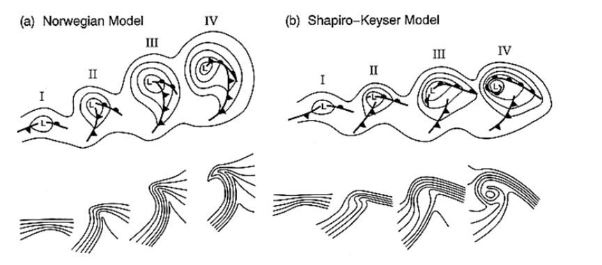
First, here's a breakdown on the evolution of Extratropical Cyclones (two models) :


Roughly:

I - warm air meets cold air, low pressure forms at centre

II - low becomes defined, frontal boundaries become defined

III - system strengthens, cold air starts to overtake the warm air at the surface. (note the disconnect in the fronts - I like the Shapiro-Keyser model) 

IV - now a pocket of warm air is broken off from the surface air- the cyclone has "spun up" and pressures fall and winds pick up big time.


SO as this happened in 2010, the fronts "wrapped up" - and suddenly - on what is technically the COLD side of the system - we had far reaching SW winds. Here is a surface map (at record intensity) - and I've added a yellow line indicating where the winds were coming from (my guess):


These big lows are the classic "rarity" setup - as far as I'm concerned - air blows into the centre from all directions and all sorts of insanity ensues. I don't think this is a classic Cave Swallow pattern - but in 2010 the storm was such a monster that it brought HUGE numbers of CASW into Ontario (probably the single largest invasion to date?). The key was this additional mechanism on providing clear(ish) skies and far reaching SW winds. The satellite image of the storm really shows why Long Point, ON had so many Cave Swallows arrive. It suited that location perfectly. (Once again I've added a yellow wind-line, and also some frontal lines):


So there we go! Three different weather patterns that have brought Cave Swallows to the Great Lakes. Zonal flow, Anafronts and exceptional Extratropical Cyclones with a Warm Seclusion. 

Perhaps new setups are yet to be discovered? These are also the weather that BRINGS the Cave Swallows to our area. FINDING Cave Swallows is another weather-dependant exercise all in itself!


(Photo taken on north winds at Point Pelee) 


Friday, October 30, 2015

Great Lakewatching at Fort Erie - 29 Oct 2015


With a gale warning in effect (40kt SW) and predicted waves up to 4m, Fort Erie was the place to be (for me). I arrived at 8am, and was entertained enough to stay in the exact same spot over 9 hours! Who needs to eat?! I was joined at various times by Josh Vandermeulen, Ken Burrell, David Pryor and Andrew Keaveney.


The wind was ripping all day, but surprised us by dropping a little bit around 11am before getting going again in the afternoon. We had some sun, cloud, lake effect showers and even some hail/sleet in the 9-10C air. Ken pointed out an unusual swirling vortex that came in off the lake - almost like a large and powerful dust devil that you would see in the summer (and over land).

It was also fun watching the water levels rise and drop. I'm not sure if the control gates would have had any effect, but there was quite the drop midday after things were really surging in the morning.

Below is a screenshot of the buoy from offshore:


The birding was as variable as the wind and waves! We had the standard morning action of ducks and loons zipping everywhere at dawn. Due to the nature of the river mouth it is hard to really know how many birds are new arrivals, but we ended up with quite a bit of variety.

There was general consensus that numbers of Bonaparte's Gulls (and perhaps Common Terns) were much lower than expected, but starting around 11am they finally began filtering in off the lake and heading up river, carrying a smattering of other species. It was non-stop entertainment in the afternoon as a steady stream passed by. Nothing was returning to the lake, so it was fun knowing that each group was entirely new birds.

The list! -

Canada Goose  100
Gadwall  40
American Wigeon  20
American Black Duck  15
Mallard  75
Northern Shoveler  10
Northern Pintail  30
Green-winged Teal  2
Redhead  6
Greater Scaup  20
Lesser Scaup  40
Surf Scoter  15
White-winged Scoter  12
Black Scoter  5
Long-tailed Duck  150
Bufflehead  80
Common Goldeneye  30
Common Merganser  40
Red-breasted Merganser  250
Red-throated Loon  3  
Common Loon  25
Horned Grebe  35
Red-necked Grebe  3
Eared Grebe  1  
Double-crested Cormorant  500  
Red-tailed Hawk  1
Sanderling  1
Red Phalarope  4  
Parasitic Jaeger  3  
Sabine's Gull  1  
Bonaparte's Gull  4000  
Little Gull  9  
Ring-billed Gull  250
Herring Gull  50
Great Black-backed Gull  7
Common Tern  10  
Peregrine Falcon  2  
European Starling  20
House Sparrow  25


The skinny:

18 duck sp.
3 Red-throated Loons (incl one juvenile)
3+ Red-necked Grebes
~4000 Bonaparte's Gulls
~10 Common Terns (low?)
2 Peregrine Falcons (harassing each other over the river at dawn)

1 Eared Grebe
~4 Red Phalaropes
3 Parasitic Jaegers
1 Sabine's Gull
9 Little Gulls


The Eared Grebe was inside a group of 8 Horned Grebes and passed by reasonably close around mid afternoon. I tried for a record shot, but it's pretty bad. I also managed a record shot of 2 Red Phalaropes and 1 of the Parasitic Jaegers. The Jaeger was really neat in that it had started molting it's primaries. I think I've only ever seen this once before in ON (with this species) and that was after Hurricane Sandy - so I figured that bird had been blown here off the ocean. Check out the pics! - 


Inner primaries dropped!


Beauty looks at Red Phalaropes all day. These two landed within 30 yards and made a few flybys just offshore! 


Teribad grebe photo. All of these shots were taken with my pocket point and shoot camera at ~25x zoom - so that should speak to how close they were... Much better looks in real life! Anyways it's the very centre bird - note the slim body and darker face - but this picture is bordering on "not useful". 


Check out my ebird checklist for more commentary on numbers etc:


Great day to be out there! 


Tuesday, October 27, 2015

This extratropical cyclone


This large mess of moisture is going to try and consolidate into a single centre of low pressure as a fairly strong extratropical cyclone over the next 2 days.


Now(ish):


A mess!


Thursday(ish):


Gales of November!!!!!!! sub 990 low over superior!!!!
(note the precip no longer shows in Canada....) screw you WPC


So what does it mean for birding? Well I hope the mess of rain on Wednesday grounds waterbirds around the S. Great Lakes... Could be a good time for large numbers of mergansers, gulls and loons. The 850mb wind level on Wednesday looks CRAZY:


(~1.5km up)


BUT - the strong S winds (at 850mb) are fully overlayed by rain. This is why i think it has grounding potential (if anything is moving) but LITTLE southerly vagrant potential (some but not exceptional potential). After the system starts to wrap up, we get some strong SW winds on Lakes Erie and ON on Thursday:


Note the better structure of the low here


The winds originate from MB in this image - so not terribly far away, but at least in Franklin's Gull territory. Personally, I would be keen on whatever waterbirds are grounded on Wednesday - OR that are already present in the region (from earlier events) becoming concentrated by the strong winds at a popular birding spot (like Buffalo/Ft. Erie)... 

As far as CASW go - the heavy rains - and then cold SW winds - do not look promising to bring any more to our area, but presumably some are around from the recent zonal flow event. 


---


The phasing of the jet in a situation like this (with a strong low) is the standard "gales of november" where we get cold arctic air mixing with warm subtropical air/moisture in our region. The low originating from the gulf of Mexico is related to the long-since-dead remnants of Hurricane Patricia that hit the Pacific coast of Mexico several days ago. The most interesting element (to me) is the fact that the low hung around Texas/Louisiana for a few days (and was decently strong) before shooting north and hooking into our weather event. The fast-moving nature of the system would be promising for interesting birds - BUT - it is my thought that the very heavy rain would block any long-distance movements. Then we are left with the "back side' of the storm, which could be quite promising for central/western birds like Eared Grebe or Franklin's Gulls (or Pacific Loons, Western grebe etc)...

The added bonus of very strong winds (esp Thursday) could help us "find" anything that was already present before the storm arrived. 

Another thing I haven't mentioned is that all air flows into these lows, so there is no reason to think that some insane rarity won't be found (if you're out looking) - it's just that there may not be reason to expect anything MORE than the typical "Gale of November"!


And if you're like me - being quite fond of birding AND stormy weather (storm birding)- boom!