Saturday, October 31, 2015

Meteorological Mechanisms for the arrival of Cave Swallows in the Great Lakes


With next Thursday (maybe weds or friday) looking like CAVE SWALLOW weather in the southern Great Lakes, I thought I'd throw down some of the meteorological patterns I have observed that were associated with Cave Swallow events... The models are still a bit variable, so I may wait a few days before throwing out the formal rarity alert. (But heads up - Tue-Wed-Thur-Fri-Sat are looking good for various reasons).

I'll also preface and say that I have NOT carefully observed CASW patterns on the east coast. If you have any additional thoughts or observations - leave them in the comments! (or email me etc)

Let's get to it!


To begin - I have a rough theory that CASW do not behave as other vagrants do. They seem (to me) to be intentionally migrating north over a period of several days to weeks, potentially even waiting out poor weather before making the next jump north. A similar behaviour would be the spring migration of Broad-winged Hawks - where you need good weather over a period of several days (to weeks) to bring the birds from Mexico north to the Great Lakes. In this scenario it is entirely possible to have amazing hawk migration weather on April 14th, but no Broad-winged Hawks - simply because they aren't close enough. Then the next day (on seemingly poor weather) - they're close enough now to start filtering past.

Similar to hawk migration - the weather not only plays an important part in bringing CASW to our area, but is perhaps equally as important in bringing those CASW to a location where birders can detect them. In my local area (Hamilton, ON) - we can have great CASW weather, but if a gentle "lake breeze" picks up out of the NE - we can't find any CASW. I presume they are flying past inland, at height - and with no concentrated flight path... When the wind finally goes south (and pushes them against the shore) - boom. There they are.

---

So with the preface out of the way, here are some weather systems that can bring CASW into the Great Lakes -
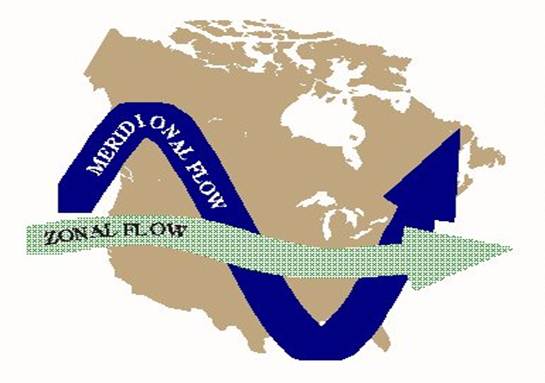
Zonal Flow!

I just talked about this for the first time in a recent blog post, where you generally have a horizontal jet stream sucking up the air - no obvious storm system - and a big old area of high pressure to the south. There is no rain in the way and prolonged S or SW winds blow in from the deep south:


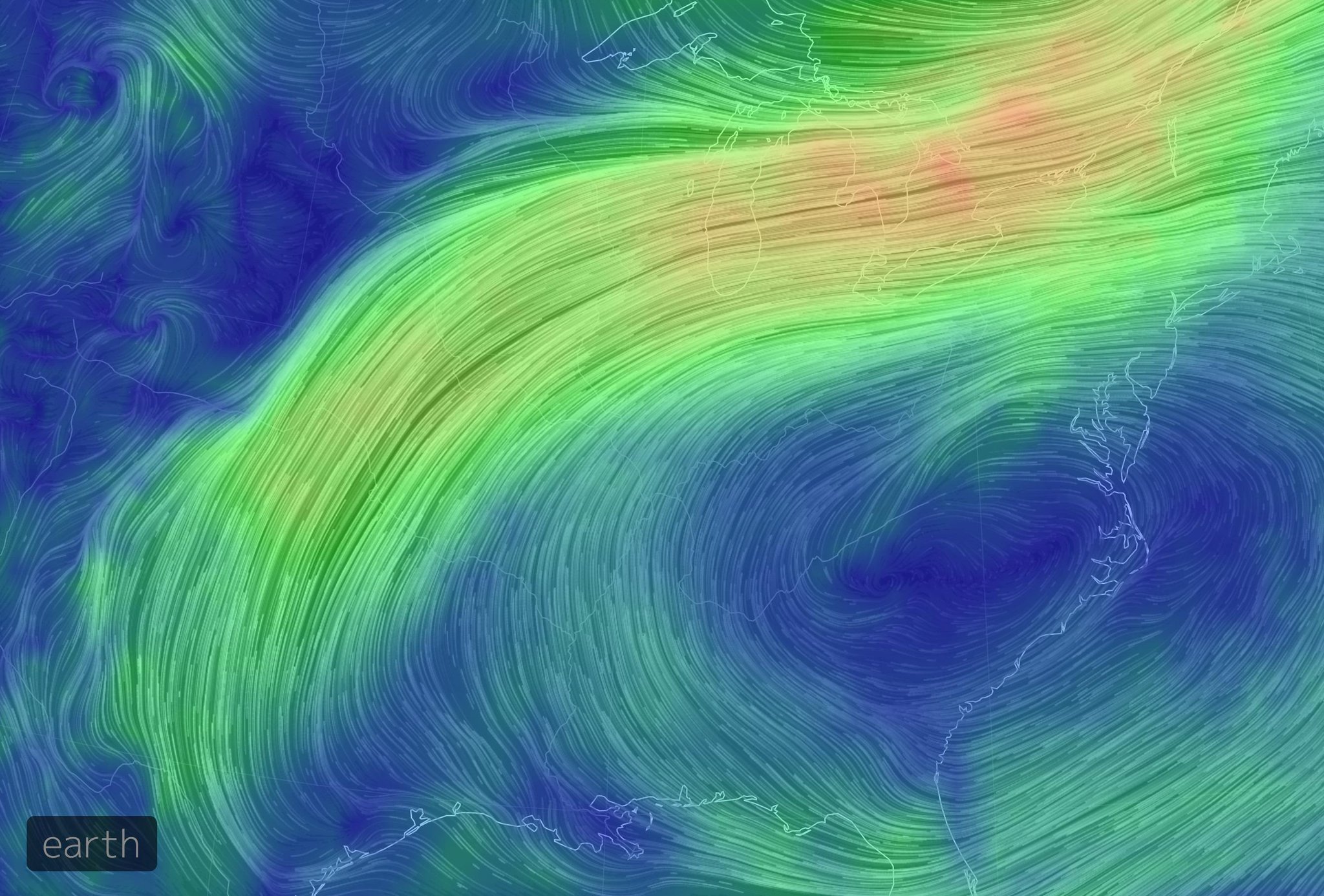
(Yellow line is jet stream, green line is wind in this image) 


There seems to be little concentration effect with this weather, so I've yet to see anyone get big CASW #'s from this pattern - but it also seems to be bonkers for bringing mega rare passerines along with it - so worth keeping an eye out for!


#2!

Anafront (type of cold front)

Meridional Flow is the opposite of Zonal Flow - where you have large kinks in the jet stream and contrasting air masses. As the air masses mix, there are various ways the warm air masses and cold air masses interact. The best (in this scenario) are Anafronts - where rain falls inside the cold part of the frontal boundary and not in the warm sector.


(note you can have Katafront A associated with zonal flow - this was just the best graphic I found for Anafront) 


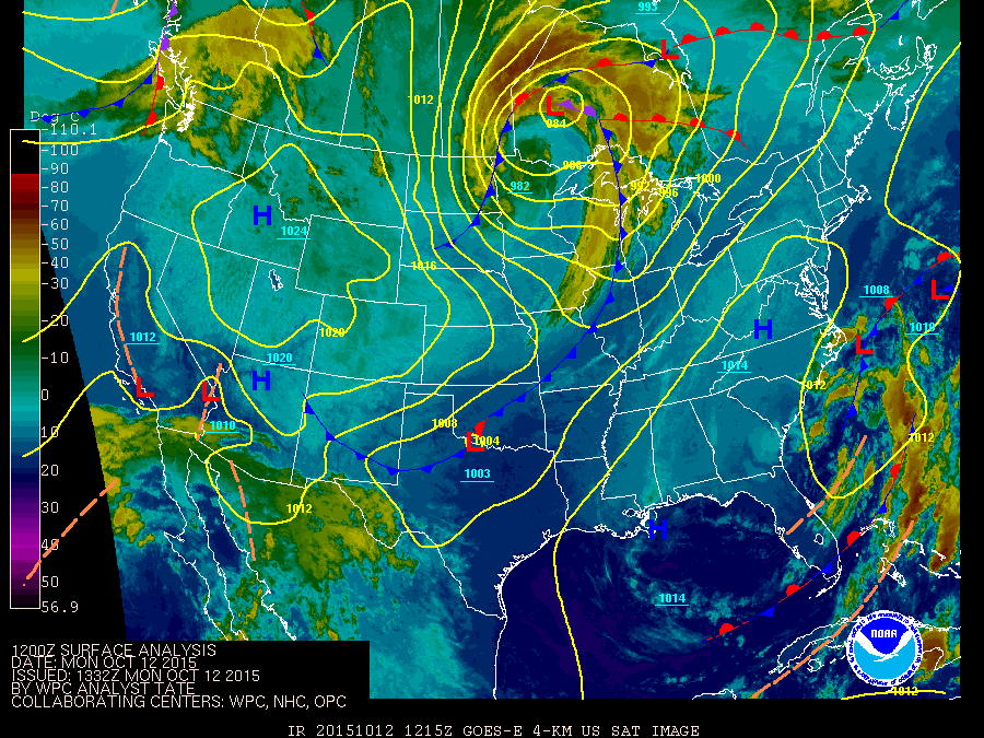
The important thing here isn't the front of cold air itself, but how the warm air is acting in advance of the arrival of the Anafront. Strong S winds (often due S) and clear to semi-clear skies. Generally you'll have a sharp cold front  dipping down into the central/south-central USA - and the associated low/warm front NORTH of the Great Lakes. Here is the surface map from Oct 26, 2012 - when we had a record count of 148 Cave Swallows in 3 hours in Grimsby, ON


This is an extreme example - but not the warm front far to the N (and the associated low) - with the far reaching cold front. I've drawn in green where the precipitation would be (guess) and the yellow line indicates the direction of the southerly air. I should also note that this storm did not act alone - 7-10 days earlier there was excellent weather to push CASW "close enough" to take advantage of this weather on Oct 26...  The S winds are strongest closest to the frontal boundary. If it were raining there (katafront) - then the strongest winds would be useless for Swallow migration! 

This setup also favours birders, who can position themselves at concentration points along the lakeshores and wait for them to fly past. I'm also not terribly sold on this setup  bringing OTHER vagrants in the fall in any great numbers. Sure, something like an austral migrant might be mixed in - and mega rares turn up anytime - but it doesn't seem as good as the other two discussed here. 


#3!

Extratropical Cyclones with Warm Seclusions

Big storms that "wrap up" into extratropical cyclones - with strongly contrasting hot/humid warm air and cold arctic air - are a pretty standard mechanism for blowing unusual birds around the Great Lakes. Many of these storms do NOT suit Cave Swallows. The last system had very strong SW winds - but they originated from MANITOBA (eg,/ not CASW home)... 

In the largest of storms, sometimes you get an occluded front, followed by a warm seclusion that serves to really strengthen the system. In October 2010, we saw the most powerful extratropical cyclone ever (inland) in North America - and it brought a TON of Cave Swallows with it. 

First, here's a breakdown on the evolution of Extratropical Cyclones (two models) :
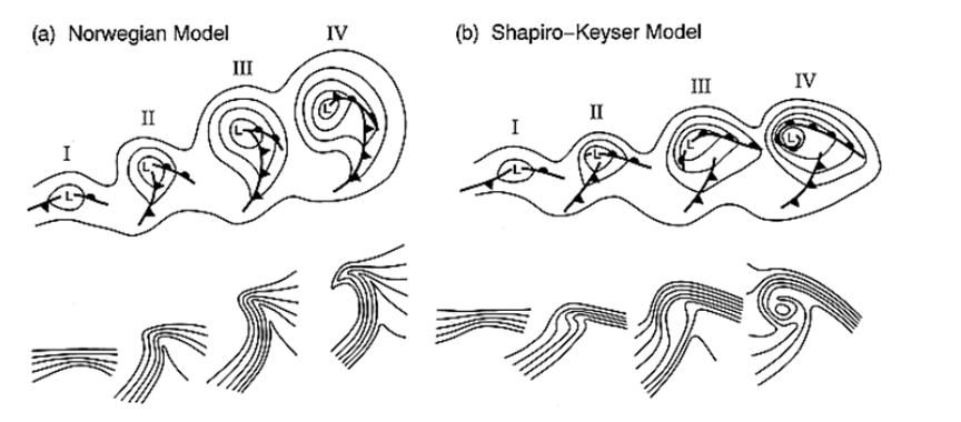

Roughly:

I - warm air meets cold air, low pressure forms at centre

II - low becomes defined, frontal boundaries become defined

III - system strengthens, cold air starts to overtake the warm air at the surface. (note the disconnect in the fronts - I like the Shapiro-Keyser model) 

IV - now a pocket of warm air is broken off from the surface air- the cyclone has "spun up" and pressures fall and winds pick up big time.


SO as this happened in 2010, the fronts "wrapped up" - and suddenly - on what is technically the COLD side of the system - we had far reaching SW winds. Here is a surface map (at record intensity) - and I've added a yellow line indicating where the winds were coming from (my guess):


These big lows are the classic "rarity" setup - as far as I'm concerned - air blows into the centre from all directions and all sorts of insanity ensues. I don't think this is a classic Cave Swallow pattern - but in 2010 the storm was such a monster that it brought HUGE numbers of CASW into Ontario (probably the single largest invasion to date?). The key was this additional mechanism on providing clear(ish) skies and far reaching SW winds. The satellite image of the storm really shows why Long Point, ON had so many Cave Swallows arrive. It suited that location perfectly. (Once again I've added a yellow wind-line, and also some frontal lines):


So there we go! Three different weather patterns that have brought Cave Swallows to the Great Lakes. Zonal flow, Anafronts and exceptional Extratropical Cyclones with a Warm Seclusion. 

Perhaps new setups are yet to be discovered? These are also the weather that BRINGS the Cave Swallows to our area. FINDING Cave Swallows is another weather-dependant exercise all in itself!


(Photo taken on north winds at Point Pelee) 


Friday, October 30, 2015

Great Lakewatching at Fort Erie - 29 Oct 2015


With a gale warning in effect (40kt SW) and predicted waves up to 4m, Fort Erie was the place to be (for me). I arrived at 8am, and was entertained enough to stay in the exact same spot over 9 hours! Who needs to eat?! I was joined at various times by Josh Vandermeulen, Ken Burrell, David Pryor and Andrew Keaveney.


The wind was ripping all day, but surprised us by dropping a little bit around 11am before getting going again in the afternoon. We had some sun, cloud, lake effect showers and even some hail/sleet in the 9-10C air. Ken pointed out an unusual swirling vortex that came in off the lake - almost like a large and powerful dust devil that you would see in the summer (and over land).

It was also fun watching the water levels rise and drop. I'm not sure if the control gates would have had any effect, but there was quite the drop midday after things were really surging in the morning.

Below is a screenshot of the buoy from offshore:


The birding was as variable as the wind and waves! We had the standard morning action of ducks and loons zipping everywhere at dawn. Due to the nature of the river mouth it is hard to really know how many birds are new arrivals, but we ended up with quite a bit of variety.

There was general consensus that numbers of Bonaparte's Gulls (and perhaps Common Terns) were much lower than expected, but starting around 11am they finally began filtering in off the lake and heading up river, carrying a smattering of other species. It was non-stop entertainment in the afternoon as a steady stream passed by. Nothing was returning to the lake, so it was fun knowing that each group was entirely new birds.

The list! -

Canada Goose  100
Gadwall  40
American Wigeon  20
American Black Duck  15
Mallard  75
Northern Shoveler  10
Northern Pintail  30
Green-winged Teal  2
Redhead  6
Greater Scaup  20
Lesser Scaup  40
Surf Scoter  15
White-winged Scoter  12
Black Scoter  5
Long-tailed Duck  150
Bufflehead  80
Common Goldeneye  30
Common Merganser  40
Red-breasted Merganser  250
Red-throated Loon  3  
Common Loon  25
Horned Grebe  35
Red-necked Grebe  3
Eared Grebe  1  
Double-crested Cormorant  500  
Red-tailed Hawk  1
Sanderling  1
Red Phalarope  4  
Parasitic Jaeger  3  
Sabine's Gull  1  
Bonaparte's Gull  4000  
Little Gull  9  
Ring-billed Gull  250
Herring Gull  50
Great Black-backed Gull  7
Common Tern  10  
Peregrine Falcon  2  
European Starling  20
House Sparrow  25


The skinny:

18 duck sp.
3 Red-throated Loons (incl one juvenile)
3+ Red-necked Grebes
~4000 Bonaparte's Gulls
~10 Common Terns (low?)
2 Peregrine Falcons (harassing each other over the river at dawn)

1 Eared Grebe
~4 Red Phalaropes
3 Parasitic Jaegers
1 Sabine's Gull
9 Little Gulls


The Eared Grebe was inside a group of 8 Horned Grebes and passed by reasonably close around mid afternoon. I tried for a record shot, but it's pretty bad. I also managed a record shot of 2 Red Phalaropes and 1 of the Parasitic Jaegers. The Jaeger was really neat in that it had started molting it's primaries. I think I've only ever seen this once before in ON (with this species) and that was after Hurricane Sandy - so I figured that bird had been blown here off the ocean. Check out the pics! - 


Inner primaries dropped!


Beauty looks at Red Phalaropes all day. These two landed within 30 yards and made a few flybys just offshore! 


Teribad grebe photo. All of these shots were taken with my pocket point and shoot camera at ~25x zoom - so that should speak to how close they were... Much better looks in real life! Anyways it's the very centre bird - note the slim body and darker face - but this picture is bordering on "not useful". 


Check out my ebird checklist for more commentary on numbers etc:


Great day to be out there! 


Tuesday, October 27, 2015

This extratropical cyclone


This large mess of moisture is going to try and consolidate into a single centre of low pressure as a fairly strong extratropical cyclone over the next 2 days.


Now(ish):


A mess!


Thursday(ish):


Gales of November!!!!!!! sub 990 low over superior!!!!
(note the precip no longer shows in Canada....) screw you WPC


So what does it mean for birding? Well I hope the mess of rain on Wednesday grounds waterbirds around the S. Great Lakes... Could be a good time for large numbers of mergansers, gulls and loons. The 850mb wind level on Wednesday looks CRAZY:


(~1.5km up)


BUT - the strong S winds (at 850mb) are fully overlayed by rain. This is why i think it has grounding potential (if anything is moving) but LITTLE southerly vagrant potential (some but not exceptional potential). After the system starts to wrap up, we get some strong SW winds on Lakes Erie and ON on Thursday:


Note the better structure of the low here


The winds originate from MB in this image - so not terribly far away, but at least in Franklin's Gull territory. Personally, I would be keen on whatever waterbirds are grounded on Wednesday - OR that are already present in the region (from earlier events) becoming concentrated by the strong winds at a popular birding spot (like Buffalo/Ft. Erie)... 

As far as CASW go - the heavy rains - and then cold SW winds - do not look promising to bring any more to our area, but presumably some are around from the recent zonal flow event. 


---


The phasing of the jet in a situation like this (with a strong low) is the standard "gales of november" where we get cold arctic air mixing with warm subtropical air/moisture in our region. The low originating from the gulf of Mexico is related to the long-since-dead remnants of Hurricane Patricia that hit the Pacific coast of Mexico several days ago. The most interesting element (to me) is the fact that the low hung around Texas/Louisiana for a few days (and was decently strong) before shooting north and hooking into our weather event. The fast-moving nature of the system would be promising for interesting birds - BUT - it is my thought that the very heavy rain would block any long-distance movements. Then we are left with the "back side' of the storm, which could be quite promising for central/western birds like Eared Grebe or Franklin's Gulls (or Pacific Loons, Western grebe etc)...

The added bonus of very strong winds (esp Thursday) could help us "find" anything that was already present before the storm arrived. 

Another thing I haven't mentioned is that all air flows into these lows, so there is no reason to think that some insane rarity won't be found (if you're out looking) - it's just that there may not be reason to expect anything MORE than the typical "Gale of November"!


And if you're like me - being quite fond of birding AND stormy weather (storm birding)- boom! 


Friday, October 23, 2015

Passerine Vagrancy in Fall + Zonal Flow


We've had a recent rash of vagrants around the Great Lakes; including (but not limited to) White-winged Dove, Common Ground-Dove, Ash-throated Flycatcher, Golden-crowned Sparrow, Neotropic Cormorant, Townsend Solitaires etc.

Oh, and HEPATIC TANAGER


The weather - hasn't been the typical storm environment highlighted by birders for vagrancy - such as large extratropical cyclones. It was rather "boring" on the storm front, but I think I'm starting to get a handle on a different weather event that brings vagrants in the fall (maybe spring too, but for now - let's look at fall). It is:

ZONAL FLOW

Per wikipedia: Zonal flow is a meteorological term regarding atmospheric circulation following a general flow pattern along latitudinal lines, as opposed to meridional flow along longitudinal lines. Zonal, in the context of physics, connotes a tendency of flux to conform to a pattern parallel to the equator of a sphere. Generally, zonal flow of the atmosphere brings a temperature contrast along the Earth's longitude. Extratropical cyclones in this environment tend to be weaker, moving faster and producing relatively little impact on local weather.

Here is a rough graphic showing how air (jet stream) and (smaller) storms would be traveling in this type of scenario:


Big dips in the jet stream allow air masses to mix, swirl, and produce high contrast areas of wind and temperature; which is what I often focus on when thinking of vagrancy weather. Zonal flow looks pretty mundane at face value, but I'm starting to see how and why we receive some excellent birds when we are experiencing a zonal flow type pattern.

I first noticed this phenomenon when studying a great vagrancy event in fall 2009, but first I'll show the recent weather maps.

Weather map from Tuesday (Hepatic day). Note the lack of strong storms - or much of anything really... (Not considering the strong storm over Hudson Bay, just off screen). But what did the 850mb (~1500m up off the surface) wind map look like? 


Long distance winds flowing from Texas into the Great Lakes, moving INTO the zonal flow and around the outside edge of a strong centre of high pressure over the eastern USA. I've marked up a few maps to show this:


Map interp (same as above) Yellow line indicating the (nearly) zonal flow of the jet. Green line is showing the direction of airflow that I would expect (just by looking at the surface map).


Real-life observations of 850mb winds (1500m up) and the centre of high pressure drawn on. 


One of my best "case studies" for Great Lakes vagrancy is early November 2009 - when we had the following birds appear in Ontario: Ash-throated Flycatcher (Pelee), Sulphur-bellied Flycatcher (Oakville) and Phainopepla (Brampton). Some "other" things found around the same time included Lark Sparrow, Summer Tanager and Western Kingbird. So what was the weather like?

The ATFL and SBFL were both found on Nov 6th, with the others coming afterwards. I am inclined to believe that birds (like the PHAI) "arrived" at the same time, it just took a few days for it to be found. So - I went straight for the maps overnight from Nov 5th - 6th:

See the similarities? I've marked it up:

Once again, the yellow line shows the "rough" zonal flow, and the green lines show the flow of air...  The little "warm front" passing over southern Ontario may have helped concentrate birds in S. Ontario more than the recent event which has them spread out over a larger area. 


Looking into this type of weather/bird event is quite interesting to me, but also raises many questions or unexpected observations:

- the Hepatic Tanager "overshot" the area I thought would be the "hot zone". Why?

- why are these birds flying north on these S or SW winds? Why don't they just stay put? 

- are there any mechanisms at play that would help one predict where the best places are? (eg, why the Hepatic showed up at WPBO)

- or is this type of setup a poor one for predictable landing spots (eg,/ 2009's Phainopepla in Brampton). 

- what happens to these birds? (This is what gives me a headache when trying to correlate birds to weather). If a Scott's Oriole is found on a CBC this Dec - is there a chance it actually arrived in ON during this recent storm?) 


While I'd be happy to have the answers to those questions, there are still some things that come into clearer focus:

-  I strongly feel that these vagrants are undertaking a single, exceptional flight over LONG distances to reach our shores.

- the mechanism for predicting "good" vagrancy weather remains unobstructed, LONG DISTANCE winds; which allows them to undertake these huge flights.


Models are hinting at some unusual weather next week - lots of moisture from the south and potential for big winds and a strong extratropical low. Not the same as this, but exciting it its own way!

Friday, October 16, 2015

Quiz Answers - Broad Scale Weather Pattern (musings)


Thanks for those who played along with the quiz! I think in some manner or another, all birds were correctly identified... With that said, I think this was tougher than expected for most?

1. Rock Pigeon
2. Sharp-shinned Hawk & Great Black-backed Gull
3. Common Terns (that highest one does look FOTE-like in the photo)
4. Sharp-shinned Hawk
5. Double-crested Cormorant
6. Black Saddlebags
7. Scarlet Tanager
8. American Pipit
9. Eastern Wood-Pewee
10. White-winged Scoter.


Expect the next quiz at a an irregular point in the future!

------------------


WEATHER!

(I like weather)... But this may not be good news. I'll try to keep this short and to the point...


We are currently engulfed in a strong el nino:


Generally... Generally... El nino does not affect our day to day weather in the Great Lakes. We are a LONG ways away from the Pacific... BUT - it does have some implication on the broad scale flow of air - and the tracks our storms tend to follow in fall winter.


A big part of this discussion/idea (about to happen) is the SPLIT in the pacific jet. Storms are going to follow that flow of air, which currently means either north of us, or well to the south...

Recently, i've been noticing that the stronger systems are tracking N over Lake Superior and rapidly towards James Bay/Quebec. The last one to do so was a monster:


So what does it have to do with rare-bird-birding?

I've noticed that "el nino falls" in the OBRC database are pretty dull, And I have a theory why. If El nino tends to enhance this "split jet" over North America, and pushes storms away from southern Ontario - then (on average) there will be less *good* days for vagrants to be blown our way.

This recent pattern (of passing over Lake Superior) seems to favour the northernwestern parts of the Great Lakes than the south. Case in point? Whitefish Point Bird Observatory has had Common Ground Dove, 4 Western Kingbirds, Townsend Solitaire, Lark Bunting, Dickciseel, Harris's Sparrows, Yellow-headed Blackbird, Arctic Tern and 2 Pacific Loons SO FAR THIS FALL...

So what does it mean? - Well I think the vagrant hunting may be a bit boring?

Small scale weather (eg,/ one storm) can totally buck the trend - making for some very exciting birding... I am just not expecting things to be gangbusters for the next 6-8 weeks...


------------

Quick edit - I also just wanted to point out how many people are blogging regularly these days. It's pretty awesome! (especially when you're stuck at work).

Wednesday, October 7, 2015

PeregrinePrints highly irregular quiz!!!!!!!!!!!!!!!!


IT'S BACK!

You know the drill. Cheat, don't cheat, leave a comment, don't leave a comment, email, don't email... And sooner or later i'll post the results online!

Identify everything!


Sunday, October 4, 2015

2015 BIG YEAR - September Update


September 2015
This is the ninth monthly summary of my 2015 CONDO BIG YEAR!!!


Red dot is my condo building


Red mark is the blue area defined in the first map


Click for - BIG YEAR RULES


The birds! (new species in bold)-
Cackling Goose - 2
Canada Goose - 528
Gadwall - 9
American Wigeon - 36
American Black Duck - 11
Mallard - 181
Northern Shoveler - 7
Northern Pintail - 228
Green-winged Teal - 72
Redhead -10
Greater Scaup - 156
Lesser Scaup - 13
Surf Scoter - 91
White-winged Scoter - 1450
Black Scoter - 5
Long-tailed Duck - 52
Common Merganser - 5
Red-breasted Merganser - 7
Red-throated Loon - 3
Common Loon - 104
Horned Grebe - 1
Red-necked Grebe - 6
Double-crested Cormorant - 1200
Great Blue Heron - 9
Great Egret - 2
Osprey - 6
Northern Harrier - 8
Cooper's Hawk - 4
Bald Eagle - 1
Red-tailed Hawk - 1
Black-bellied Plover - 2
American Golden Plover - 1
Killdeer - 8
Spotted Sandpiper - 1
Hudsonian Godwit - 42
Sanderling - 1
Red-necked Phalarope - 34
Pomarine Jaeger - 1
Parasitic Jaeger - 12
Sabine's Gull - 3
Bonaparte's Gull - 2
Little Gull - 2
Ring-billed Gull - 2550
Herring Gull - 370
Lesser Black-backed Gull - 9
Great Black-backed Gull - 13
Caspian Tern - 28
Common Tern - 327
Forster's Tern - 1
Rock Pigeon - 16
Mourning Dove - 35
Yellow-billed Cuckoo - 1
Common Nighthawk - 2
Chimney Swift - 6
Ruby-throated Hummingbird - 3
Red-bellied Woodpecker - 1
Yellow-bellied Sapsucker - 1
Downy Woodpecker - 10
Hairy Woodpecker - 2
Northern Flicker - 8
American Kestrel - 2
Merlin - 2
Peregrine Falcon - 9
Eastern Wood-Pewee - 1
Yellow-bellied Flycatcher - 1
Warbling Vireo - 5
Blue Jay - 20
American Crow - 1
Common Raven - 1
Tree Swallow - 1
Barn Swallow - 112
Black-capped Chickadee - 28
White-breasted Nuthatch - 1
Brown Creeper - 11
Blue-gray Gnatcatcher - 1
Golden-crowned Kinglet - 18
Ruby-crowned Kinglet - 1
Veery - 2
Gray-cheeked Thrush - 1

Swainson's Thrush - 27
American Robin - 50
Gray Catbird - 2
European Starling - 195
Cedar Waxwing - 79
Ovenbird - 1
Northern Waterthrush - 1
Tennessee Warbler - 11
Nashville Warbler - 22
Common Yellowthroat - 1
American Redstart - 30
Cape May Warbler - 5
Northern Parula - 5
Magnolia Warbler - 17
Bay-breasted Warbler - 26
Blackburnian Warbler - 3
Chestnut-sided Warbler - 1
Blackpoll Warbler - 14
Black-throated Blue Warbler - 3
Yellow-rumped Warbler - 3
Canada Warbler - 1
Wilson's Warbler - 6
Chipping Sparrow - 1
Dark-eyed Junco - 4
White-throated Sparrow - 43
Northern Cardinal - 11
Rose-breasted Grosbeak - 4
Red-winged Blackbird - 12
Common Grackle - 116
Brown-headed Cowbird - 1
House Finch - 41
American Goldfinch - 57
House Sparrow - 80

Total species - 115


Total ebird checklists - 23

Best birds of the month: Hudsonian Godwit (42), Pomarine Jaeger, Sabine's Gull (3), Little Gull (2), Red-necked Phalarope (34), Common Raven

Useless seasonal rarities: Junco? Not much is unseasonal in September...

Highlight "big year" birds: Gray-cheeked Thrush, Veery, Yellow-billed Cuckoo, American Golden Plover

Checklists of the month:


Total species added to the big year this month: 13


Big year total to date: 188


Target species going forwards: October has some darn good birds to be found... There are many passerines that I'm still hunting for, but Gannets, Cave Swallows, Kittiwakes and Harlequins seem much more appealing.


eBird needs alerts - Many are the same as before House Wren, Swamp Sparrow, Scarlet Tanager, Field Sparrow, Eastern Towhee, etc... Least Flycatcher, Black-and-white Warbler and Black-throated Green could be embarrassing though...


KM driven: 0

KM flown: 0

KM by boat: 0

KM by train: 0

KM by helicopter: 0


(1 Kilometer = 0.621371192237334 Miles)


Previous summaries: January | February | March | April | May | June | July | August |


Thoughts:


Last month I said September is the poor-man's May. And it was! I scored 2 Thrushes, 6 Warblers and 3 Shorebirds for the big year. AWESOME POSSUM.


October says 75% of my big year is over. Where does the time go? Not only that, but i'm on the wrong side of the calendar as many target species are starting to laugh at me on route to South America (*cough* Black-and-white).


There are still a few "targets" (I guess) that migrate through in October. Some will be ridiculously challenging from the 17th floor, but I think I'm up to the challenge. I'm looking at you - Towhee, Winter Wren, Blue-headed Vireo, Greater Yellowlegs, Hermit Thrush, AND OTHERS...


My efforts may be hindered though as October is a pretty nifty month for vagrants. As I write this (Oct 1st), the windows are rattling with NE winds and thoughts of Kittiwake are dancing. Harlequin, Brant, Gannet, Cave Swallow, etc would all be nice... Just not as nice as a Manx Shearwater.


Anything else? I feel like this is a repeat of September. Just bird! Lots to see, weather is key.


September 6th


September 13th


September 27th


Thursday, October 1, 2015

The devil you know


Unfortunately it doesn't look like the blog will be switching into Hurricane mode... We still don't know for sure, but the current spaghetti is not looking favourable.


Not only is there dissapointment from Great Lakes birders from this type of news; the people currently in the Bahamas are wishing Joaquin was never born... The Hurricane is now Category 4 and is wreaking ungodly havoc on those poor folk. Hoping it is not as bad as it looks from the satellite images....


SO - what about the devil we know? 


35 knot NE winds in early October? You gotta be kitten me! A few days ago I was yammering about this being Kittiwake weather - AND IT IS.... But it's probably not as good as it looked a few days ago. I guess we can't catch a break!

The inverted front wants to become more of a cutoff low - sending our cane to sea and reducing the distance and intensity of our "feeding winds". This is my old standby of rare bird finding - you need the winds to be COMING from somewhere exciting. 100kph winds from Kingston to Hamilton brings Kingston birds (zzz)... We want winds from Newfoundland !!!


For the next 24-48 hours, winds ARE coming down the St. Lawrence, and will hopefully bring the Kitti's (and something bonafide mega-ish)... They just aren't as strong (at the source) as they were looking a few days ago... 


Then by Sunday; we're still lookin at some ballin NE winds on the Great Lakes - but our source has been crushed by high pressure - even pushing birds away!


On top of that, I have this uneasy feeling about all of this sunshine in the forecast. I know it isn't much; but I like my rarities with low (rainy) pressure.... Looking back, I think some of my most disappointing days of lakewatching have occurred during a strong wind + sunshine...

Thankfully it only takes one bird; and a stormy lake is pretty exciting on it's own. Should be very good for rapid passerine and raptor migration too! I have had great luck at Pelee on NE winds in the fall, so hopefully everyone has a blast at the OFO conference this weekend. I'll be jealous if a huge Turkey Vulture migration shakes down.