Tuesday, April 26, 2016

Meadowlarks: Impossible Identification?


Can anyone even identify these things?

Point Pelee - April 25th - Serengeti Tree

I feel a little too close to this thing to bother trying to dive into the ID, so instead I send out the challenge to someone more skilled to put a name on it. Obviously I didn't take all these photos because I was hopeful it was an Eastern mind you... Looked quite pale. Didn't vocalize. Not able to say either way... It could be a Lilian's for all I know...

So?! What is it?!


Added a few more:


10 Fish Crow photos from Point Pelee


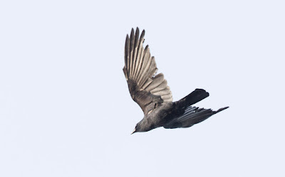
This beauty Fish Crow flew around the tip of Point Pelee several times (reverse migration!) on Monday... The handful of birders present were treated to a handful of nasal "uh" calls as it circled about. It was quite low, and as far as a "boring, black, crow" goes, it was actually a pretty exciting observation. 


I snapped a bunch of photos (as it was often quite low) and gave several passes. I've converted a few different 'looks' here.


Visual ID of these birds is pretty darn tough in my opinion - and it's a bit of a cop-out to talk about it (when we heard it call) - but I really did think that I could see some structural/GISS differences from this bird and the numerous AMCR I watch/photo flying past my condo each spring...

Some rough thoughts:


1. Long head
2. Long narrow (more rectangular than square) wings
3. tail seems more "pinched" at the base
4. Tail seems long and narrow. 


I put my amazing artistic skills to the test and did an exaggerated example of the differences on the left...


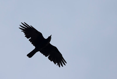
Also - there's that issue of the "primary formula" that everyone loves... I find it very unreliable without the best photos (and a number of examples) - but it works out ok with this bird (despite the damaged feathers):


I don't have a great AMCR to compare with, and have struggled with this in the past (thanks to those who have helped) - but with FICR you have a bird that has P9 a bit shorter than it looks on AMCR, with P8 and P7 looking rather long compared to the other "fingers"... Then P6 and P5 once again look shorter on the FICR than they would "appear" on an AMCR... 

P5 especially starts to "blend into the wing" and barely stand out as a "finger"... Whereas it should still be rather obvious and longer on AMCR...

It's not great, but there you have it!!!


-------------


Weather note:

My Sunday/Monday forecast and expectations fizzled a bit, despite both days being quite good. I was just thinking it would be better.... Then Tuesday (today) broke expectations by having rain hit Pelee overnight... I'm dying to hear if there are lots of birds around or not... Looking at Radar, I think Ohio will be reaping the benefits more than Pelee - but you never know until someone in the field reports!... 


The next week (or even two weeks) would be AMAZING weather... If it were early September... But it's not early September... So I'm a bit bummed out at the prospects of weather-related-birding... I guess we'll see how it plays out. 


Saturday, April 16, 2016

The birds approacheth (first ALERT of the year)


Sometimes I feel silly for making these posts... Tomorrow and Monday are poised to be the "best" days of this beauty sun and high pressure we've been experiencing (especially because Monday will finally burst the bubble) - but why not talk about NEXT Sunday and Monday instead?

Models are kicking around the idea of a significal low pressure / strong S or SW flow event .... Likely starting Sunday morning (give or take a day) and ending Mon-Tue (give or take a day)..

Each model run is different, but 75% look very promising for an early season blast of birds...


Sunday via one model run of the GFS (precip, pressure etc) 


Monday via one model run of the GFS (850mb winds and vorticity) 


Tuesday via one model run of the GFS (precip, pressure etc)


Each of these is bringing the much-desired "long-distance" S to SW winds (fairly strong too) with varying amounts of precipitation....

In most runs, it holds well north of Lake Erie (and area), so while it reduces the odds of a huge grounding of birds --- it also decreases the odds of a day being a complete and total bust...


Sunday via one model run of the ECMWF (850mb winds, vorticity) 


Tuesday via one model run of the ECMWF (bit different than the others, eg. not the current norm - but looking gooood).. (850mb winds, vorticity).


So there you have it. If I were a betting man, i'd say this is 7 days notice to some darn good days birding... AKA seven days to plan your workload and get that doctors note to take a sick day or two...


(so close you can TASTE it) 


Oh - and the next day or two will be beauty weather / great days to be outside - so don't forget to get out and enjoy it!

Wednesday, April 13, 2016

And so it begins...


Several days of high pressure settling in to our area...

- Solar heating (daily) will gradually increase temperatures to a peak on Sunday or Monday...

- Heat will escape on clear skies each night (cool nights and early mornings)

- The Great Lakes will keep the land nearby cool

- Winds will generally be light, but could pick up from the NE at times


In the centre of the continent, some impressive migration may unfold (closer to the jet)... 

Around Lake Ontario/Erie, I suspect that birds that are late/behind (eg,/ Vultures, Osprey, Chipping Sparrows, Barn Swallows etc) - will start to move in with each passing day - BUT - with fairly "boring" weather, I wouldn't suspect anything too crazy (eg,/ neotropical migrants)... But you never know...  

Regardless - it's a fun time of year and i'm excited to see what shakes down! 


Thursday, April 7, 2016

Longer range weather guessing


Despite the weather, it's the time of year to start getting all anxious and jittery about what may be just around the corner... Neotropic Migrants have hit the USA, and could appear on your borders anytime with the right weather conditions...

SO - a rapid post on some of my favourite things to look at, and what is coming...


First - CPC's 6-10 and 8-14 day outlooks:


http://www.cpc.ncep.noaa.gov/products/predictions/610day/index.php

http://www.cpc.ncep.noaa.gov/products/predictions/814day/


The 6-10 day outlook is cool, but the 8-14 day outlook is showing a 30-60% chance of "above normal" temperatures for our area....


Model Runs: My two favourite sites for model data:

http://www.tropicaltidbits.com/

https://www.wunderground.com/wundermap/


Model runs are NOT forecasts. Use several different runs from different models (esp GFS and ECMWF) to get a rough idea on what might happen... Know what they're saying?


Above average temps in the Apr 16-18 timeframe... Brought about through high pressure... 

ECMWF


Also calling for warmer than normal temps, but a different setup... Compare the 850mb winds above with the run from the GFS for roughly the same time:


It's totally different!

So what's the moral of this birdy/weather story?

It's much too far away to get excited about weather. (240hr forecasts are the extreme limit at the best of times) - BUT we can say that it looks "interesting" in this timeframe... Otherwise, I'm not expecting any big fireworks for at least 7 days..

And at that, it is likely (at best) to be a 1-3 day spurt of warm weather, before we await the next... So 10-14 days of limited action may be in store...

Would be nice to see more surges of great weather (March was pretty darn good) - but I'm also quite happy to "save it up" for May


A(nother) big update (for me) will happen Apr 21st!

http://www.cpc.ncep.noaa.gov/products/predictions/long_range/fxus07.html


Friday, April 1, 2016

Condo Neotrop - April 1, 2016


They just keep on coming...


Some other recent sightings (ain't migration amazing?):

Caspian Tern - Apr 1
Osprey - Mar 31
Purple Martin - Mar 30
King Eider (adult male) - Mar 26
Golden Eagle - Mar 12

Also scored a great flight of Tundra Swans this year. Over ~2200!