Wednesday, October 31, 2012

Frankenstorm birds from Oct 31, 2012


Today was apparently the "lull" day?


Birded at various times with Dave Don, Barb Charlton, Ken-tucky, Peter Burke, Ross Wood, Kevin McLaughlin and a few others!

Highlights:


Van Wagner's Beach pre-dawn - 1 White-rumped Sandpiper on the beach


50 Rd in Grimsby (Lake Ontario) :

2 Pomarine Jaegers -- with 1 being a winter-adult type.. This is a DISPLACED hurricane bird (in my opinion)

1 Jaeger sp

2 Red Phalaropes (that only Ken-tucky saw)

2 probable White-rumps (distant)

some Snow Buntings...

LOTS of scoters and loons

1 Glaucous Gull

12-ish Brant

some Bonaparte's Gulls...

highlight was a Forster's Tern - a very good bird for Hamilton at this time of year, and for sure a "Hurricane related" occurrence.. Some record pics:


Only waterbird I photographed today, might as well put a few up.... 


We also watched a Sharp-shinned Hawk catch a Golden-crowned Kinglet at close range and right in the open (VERY close range for something like this).. It was AWESOME

---


Then went for Fort Erie and the river for a few hours... 

Waverly Beach:

Peregrine Falcon - 1 juv

Little Gull - 1 ad

Forster's Tern - 1 (distant when I saw it) 

2 Greater Yellowlegs

All 3 Scoters + LTDUs

Both Loons

LOTS of Bufflehead and some other ducks...


Above Niagara Falls

25-30 N Rough-winged Swallows

1 Orange-rumped Swallow that has a 99.6% chance of being a Cave Swallow

3 Lesser Black-backed Gulls


Gorge - 2 Common Loons ...


Adam Beck  - nothing


Niagara-on-the-lake:

2 Brant

=========


Another very fun day, even without any CMF's ... You know it's fun birding when you constantly jump every time a bird looks slightly different... 


Hurricane Sandy


A song I have on CD in my car (has been in there for about 3-4 weeks)


Mind Eraser - The Black Keys

Fitting for Hurricane Sandy? Lyrics below... 


When I need to replace her
I am the mind eraser
Anything goes, yeah, anything goes

Got this sin in her brain
But she ain't gonna see me again
See me again, this I know
But oh, deep down I can't let go

Oh, don't let it be over, over oh
Oh, don't let it be over, let it be over, over

Seen me stack up my woes
Into a wall, around a rose
Now I'm the rose, now she knows
Oh, it hurts so, and I can't let go

Oh, don't let it be over, over, oh
Oh, don't let it be over, let it be over, oh oh

Oh, don't let it be over, over
Oh, don't let it be over, let it be over, oh.


==================================


Working on the sightings from today.... Will be up later tonight ... The storm is totally over from a meteorological stand point, so there is little I can "update" on that regards...

Let's clean up those mega's! Now all that is left is birding, or as they say:

Bird is the word


Keep an eye on the sky


Rare birds everywhere... Another auto-post


AMAZING photo:

http://www.flickr.com/photos/seabamirum/8140168102/in/pool-437129@N20


==============


Keep your eyes peeled on Ontbirds:


http://birding.aba.org/maillist/ON


Nemesis bird:

http://www.nemesisbird.com/2012/10/tropical-storm-sandy-rare-bird-liveblog/


Genesee Birds:

http://birding.aba.org/maillist/NY04


The wind map (follow the winds!)


http://hint.fm/wind/


And just bird.... Just bird...


Tuesday, October 30, 2012

Phase 3 of Frankenstorm was FANTASTIC


Just wow....


Phase 3 - direct winds from the east coast onto lake Ontario (skipping the St. Lawrence Seaway)...


Here's hoping phase 4 works out as well, because phase 3 was GREAT... (the phases add up mind you, so we can still get all the same birds from the previous vagrant paths as well)...


Phase 4 is when we get the centre of the storm to pass over Ontario... And hopefully we get some of the warm weather birds being reported like Oystercatcher, Royal Tern, Skimmer - and maybe some Shearwaters? Maybe some BC Petrels or Sooty Terns?!


===============================


Strategy for tomorrow - BIRD... BIRD IS THE WORD


There are rarities everywhere, the track of the storm is over Lake ERIE now and ALSO lake Ontario!!


The storm is huge, and there are clearly rarities to be found over a wide area...


Maybe focus on onshore winds, but who really knows?? Maybe Lake Erie will get the real tropical stuff? Or maybe they'll come to the east of the storm and Lake Ontario will continue to be the hotspot?! 


Or maybe we won't get some of those birds, so we should continue to do what we did today!? Since clearly Ontario birders did a pretty good job of finding some epic birds today.....


Ok, here's the plan:  Peter Griffin breaks down exactly what we need to do: 


Bird is the word! Long Point East, The river, inland spots to Lake Ontario - ALL of Lake Ontario and eastern Ontario too!!!!!

Just bird!


wow..... photos of the first Leach's Storm Petrel ... Sandy/Frankenstorm.. wow...


The Northeast Atlantic Ocean came to Lake Ontario today... Not sure what else can be said... Will post the full days highlights later, but wanted to get the photos up. Unbelievable birding... 


=========================================

8pm edit: 


Barb "Wire" Charlton did an awesome ontbirds posting from our days sightings.. I was there from 7:20am to 5:40pm ....

I edited it a bit to reflect some of my personal sightings etc... but many thanks to her for putting together the post for us! What a day!!!! 


Ontbirders: 

 Today was, very simply, an unprecedented day of birding at Van Wagner's Beach in Hamilton! The dozen or so birders that spent approximately 10 hours at Hutch's today (some who arrived pre-dawn) felt an Ontbirds post, in summary of such an outstanding day, was warranted. 

Here are the highlights: 

 75 Snow Geese (a single large flock) 
281 Brant (several large flocks as well as a few smaller flocks) 

*1 Wilson's Storm-Petrel (spotted by Rob Dobos)* 
*1 Leach's Storm-Petrel (spotted by Dave Don. Photographed by Brandon Holden and David Bell)* * *
2 Storm-Petrel sp. (not identifiable to species) - (I only saw one of these birds)

2 Purple Sandpipers (flying by) 

*88 Black-legged Kittiwakes ( flocks of 5-8 all morning,18 in view at one time, 2 adults)* This may easily be an under count.. How do you count? It was the Atlantic ocean out there... 

16 Bonaparte's Gulls 
5 Lesser Black-backed Gulls 
1 Glaucous Gull 

 6 Pomarine Jaegers 
7 Parasitic Jaegers 
1 Long-tailed Jaeger   ---- 3 Jaeger day!

2 Peregrine Falcons 

21 Jaeger sp. (distant and unidentifiable) 

 There were also quite a number of birders at Lakeland Centre, further down the beach from Hutch's, who had a similarly exciting day seeing the Storm-Petrels, as well as the staggering number of Kittiwakes, Jaegers etc. All in all, an absolutely amazing day of birding in the Hamilton Study Area that none of us will soon forget! We can only hope that the next few days and weeks hold even more excitement for Ontario's birders!! 

 Cheers, Barb Charlton


Top 10 birds I would really like to see involving this storm...


Birds get points for two things - rarity, and my feelings on their likeliness to occur ,, to create a top 10!

PS - this is just for fun....


10. Laughing Gull --- see one of these, and it will only get you stupidly excited about what else could be out there (indicator)

9. Barnacle Goose - still sticking with my "odd" prediction of this species in Ontario...

8. Northern Gannet --- coming down the St. Lawrence please!

7. Northern Fulmar - could come from 3 directions (hopefully at least one)

6. Sooty Tern --- one of the "classic" Hurricane birds, hopefully we can get lucky and get a few!

5. Black-capped Petrel  ---- THEE classic hurricane bird? A much weaker storm in 1893 brought them to Lake Ontario.....

4. Royal Tern --- Hitting places that still have Royal Terns on the east coast... Maybe a hard one to displace, but I still want it!

3. Magnificent Frigatebird --- Sandy was strongest in a frigatebird-rich area...

2. Dovekie --- well known to not handle "big winds" nearly as well as other alcids

1. Leach's Storm Petrel  ---- same as the Dovekie, but I need this one for my Ontario list, so I gave it the bump to #1


========================


Ok here's a top 10 that I really REALLY want


10. Black Skimmer

9. Atlantic Puffin

8. Pink-footed Goose

7. Cory's Shearwater

6. Black-browned Albatross

5. White-faced Storm-Petrel

4. Skua species

3. Brown-chested Martin

2. Non "Black-capped" Pterodroma

1. WHITE-TAILED TROPICBIRD!!!


ebird and sandy


Ebird strategies  (newer):


http://ebird.org/content/ebird/news/hurricane-sandy-strategies


Ebird thoughts on species (older):


http://ebird.org/content/ebird/news/hurricane-sandy


Be sure do document any rarities you may get with the OBRC and then put them on ebird!! ;)


Storm bird info


Since I don't have a smartphone, the best ways to find out what I (or others) are seeing is Hamilton Birds:

https://groups.google.com/forum/?fromgroups#!forum/hamiltonbirds


Or Ontbirds:


http://birding.aba.org/maillist/ON


=================================


Also for fun again:


Nemesis bird updates:

http://www.nemesisbird.com/2012/10/tropical-storm-sandy-rare-bird-liveblog/


Birdcast storm updates:


http://birdcast.info/


==================================


Sorry I haven't been answering many emails...... Birds on the brain.....


sandy on Tuesday morning


In relation to track, Sandy continues to do crazy things.... I'm going to stick to my plan for today, then re-hash some final thoughts tonight... 


She has been inland for close to 12 hours now, but barely so... Hopefully she can still push some birds inland for us in this time frame


She is also weakening rapidly... Keep your fingers crossed she doesn't dump ALLL of her birds over Pennsylvania 


Be careful out there, and hopefully everyone is alright in the affected areas... I  had to go for a short drive last night and ran into downed signs and trees along the way. 


Thanks to Tyler Hoar for these next two:


Birding Frankenstorm: day 2


Spent 9.5 hours at Van Wagner's Beach today......


Going to keep this short and sweet because I'm reaching the point in time where I need more sleep and prep time than blogging time....


The skinny: it was SLLLOWWWWWW


Hopefully the calm before the epic  birding....


Some highlights from the day:


3 Lesser Black-backed Gulls (juvies)

1 2nd winter Kumliens' Iceland Gull

1 Sanderling

2 Greater Yellowlegs

2 Peregrine Falcons

1 ad male Black Scoter (rarely see Ad males here.. Female types every day, but no males)

1 Red-necked Grebe

1 Bonaparte's Gull (more typical VWB fashion - but why the crazy shift from yesterdays total?)

10 BLACK-LEGGED KITTIWAKES 

Had 1 around 1:30, then 20ish minutes later, a flock of six flew RIGHT up the beach... I was there with Hugh Currie, and we were very excited to see this... 2 more 10 minutes later,, and  1 a few hours later...


One bird was a 2nd winter "adult" ...


It was exciting because it was proof (to me) that we were now getting birds from the St. Lawrence seaway.....

I was expecting all heck to break lose, sent crazy texts to all the birders I have in my phone (which is limited, because I switched phones less than a year ago and didn't save my contacts)... But yeah... exciting, considering it was just kittiwakes...


Some pics:


Ain't that a thing of beauty??


Sleep time!!!


Monday, October 29, 2012

Dandy Sandy Plan for Tomorrow


The plan!!!!


Lake Ontario eastwards.... Ottawa area and the St. Lawrence river!


East winds in the forecast........


As of writing (7pm) we DO NOT have any direct connection to Hurricane Sandy and Ontario...


What we DO have is N and NE winds from James Bay and the St. Lawrence River...


What I'm thinking....


James Bay goodies ---- Fulmar?? Gyrfalcon??? Red Phals?


East Coast Goodies - Kittiwakes? Great Cormorant? Dovekies? Gannet? Razorbill? Manx Shearwater? Leach's Storm Petrel???

Obscure - Pink-footed & Barnacle Goose  -- Northern Lapwing...


Places to look:


Niagara River Gorge (if you're close)

Niagara on the Lake

Port Wellar

Jordan Harbour

Fifty Point C.A.

Van Wagner's

Hamilton harb

Bronte Harb

Port Credit

--- all those weird places around toronto on the lake that I never go...

Cobourg Harbor

Presqu'ile

PEC (Point Petre, PEPtBO)

Then pretty much anywhere on the water east and north of there...


Pretty much - go out and check your local spot if you only have a few hours..... If not, bird till you drop....


===============

Remember the phases from an earlier post?


Phase 1 - James Bay birds dropped


Phase 2 - direct winds from James Bay and then the St. Lawrence Seaway


Phase 3 - direct winds from the east coast (MA, NY etc) hitting Ontario  (connection to Sandy)

Phase 4 - leftovers of Sandy pass over Ontario (hopefully)


===============


We just started phase 2 this afternoon..... Waiting for phase 3 --- hopefully tomorrow


WHAT da HECK?! Sandy making landfall!!!!!!


Sandy wasn't supposed to make landfall until late tonight... From what I'm seeing, she's pretty much ashore now!!


Nemisis Bird live blog for Sandy/Frankenstorm


If you don't know, now you know!


http://www.nemesisbird.com/2012/10/tropical-storm-sandy-rare-bird-liveblog/


Check it out for live updates on bird sightings related to this storm!


=====================


Current NHC track


Current Wind Field:


Tropical tidbits...


]


Yesterdays tropical tidbit from Levi:


Make sure you check out his site for all future hurricane needs:

http://www.tropicaltidbits.com/


I think we're reaching the point where people are focusing on the potential damages with these news sources..... Rather than how many rare birds Ontario could get (depending on the exact track)!

We're going to have to wait it out.....


====================


Don't forget to check out Dr. Master's blog as well:

http://www.wunderground.com/blog/JeffMasters/show.html


=========================


Bird cast is also doing updates! :

http://birdcast.info/


Early morning track update + strategy


From what I'm seeing with the tracks, there may be a real possibility that the best birding may be in the Kingston area and eastward......


Maybe time to go mobile??


Will continue to keep an eye on things (get it?)


So what's the plan?!

Well it's too far away to be honest...


For now: we are still in the very very early stages of this system....


I'll be focusing on Lake Ontario for birds from James Bay (Jaegers, Kittiwakes, Shorebirds).... Although things are getting more interesting in that we could be reaching stage 2 soon -


State 2 - the chance for birds from the St. Lawrence Seaway!  Maybe NE winds (by late today?) could have been blowing long enough to bring other interesting species like Gannets, more Kittiwakes, Manx Shear?? Or maybe some alcids?!

Probably too early, but the possibility of "NE coast" alcids shoudl be watched - eg,/ Dovekie, Razorbill and maybe Thick-billed Murre.....


Beyond that, I just don't know...


Wednesday is going to get interesting... (east winds FROM the coast , maybe?)

Thursday could be the day when some real CMF's arrive and first discovered (weak remaining centre passes over Lake Ontario) 


Friday-Sunday could be some damage done to the gas tank when things really start getting found...


==================


Always remember, this storm is totally unprecedented and we don't really know what (if any) birds will get moved around...

I give it a 25% chance that it blows Hurricane Fran out of the water and shocks us all with crazy sightings


and a 25% chance that virtually no "Hurricane birds" are found in Ontario....


Then a 50 % chance that it will bring some excellent birds, and most of us will go out looking (feel like we're working very hard), feel like we aren't seeing what we were expecting... Twitch some rarities, find something else.... etc etc etc

And 2 weeks from now (or 2 years from now) you'll come to realize that rare birds are rare, and you actually saw a very respectable haul of incredible birds 


Sunday, October 28, 2012

First birding with Frankenstorm


Late night = late start this morning...


10am to 1pm at Van Wagner's Beach


Highlights:


50ish Brant in 2 flocks

30ish Sanderling in 1 flock (had more, but not sure if its the same flock) --- these and the Brant are the birds being forced down on route from James Bay (or elsewhere in the north)

1 Juv Thayer's Gull

Lots of Bonaparte's Gulls (200?)

4-5 Red-necked Grebes on the wing

All 3 scoters (big numbers of Surf and WW)

Several individuals of both loon species

pretty much every other duck species you'd expect


======================

Decided to take a break for the boring mid-day part... Didn't want to burn myself out for the fun we're going to have over the next few days...

Think I'll go back for a few hours this evening...


Some pics:


Sandy / Frankenstorm


I'm already starting to forget what I've posted and haven't posted already for the blog ....... As Tyler put earlier, I do feel like a kid waiting for Christmas...


An awesome long loop of Sandy:

http://rammb.cira.colostate.edu/templates/loop_directory.asp?data_folder=dev/lindsey/loops/goes14&image_width=1020&image_height=720&number_of_images_to_display=50


========================


Sandy is trying to block out the dry air bothering it, and is trying to form an eye........ This is muchos better for bringing rarities methinks  :)


click to see 


======================


click to see 

one of the largest storms ever...... 


=======================


Models seem to be trending towards an eventual passage over the great lakes (Lake Ontario)

Although it will be weakening very rapidly by the time the centre gets close to us


====================


Global Forecast System ------ 40 hours after landfall ----- the centre of Sandy's wind field directly over Lake Ontario ---- Wednesday at 9pm


I REALLY hope this happens.......... 


Sandy info


Excellent visible detail look at Sandy:

http://rammb.cira.colostate.edu/templates/loop_directory.asp?data_folder=dev/lindsey/loops/goes14&image_width=1020&image_height=720&number_of_images_to_display=50


Western Lake Ontario Marine forecast --- still a chance for 100kmh NE winds early tuesday:


http://www.weatheroffice.gc.ca/marine/forecast_e.html?mapID=11&siteID=08207


Rainbow Loop:  looking more like a  hurricane this morning, pressures continue to fall (951 at time of writing!!)

http://www.ssd.noaa.gov/goes/east/eaus/flash-rb.html


Current wind field is extremely large, and will get bigger... Already twice the size of Irene last year:


Hurricane Centre:


Weather underground tropical:


===================================


The models are still flip flopping a bit about how GOOD the path of the storm will be for us in Ontario, it's not nearly as good as it could be (forecast for right now)... But I still think we can make due and find some excellent birds based on the patterns I'm seeing...


Still have to watch and wait!!! 

Time to start birding methinks,... Will get out a bit today... .


Yesterdays tropical tidbit from Levi


here:


Saturday, October 27, 2012

Frankenstorm... please come for a visit.. Please??


Part of a post that I did on Hamilton birds this morning:


---
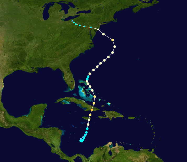
The approach of Hurricane Sandy (a hybrid storm, also going by the name Frankenstorm, due to its expected impacts around Halloween) is now of great interest to birders in Ontario. The exact track the storm, which is very difficult to predict at this time, will likely determine the birds that could be displaced by the system. To start, winds should increase from the north to northeast as the system approaches. Birders in Ohio this morning reported record numbers of grounded waterfowl such as Scoters, Harlequin Ducks, Brant and even a probable Common Eider. By Monday evening, winds in Hamilton could be approaching 100kmh from the NE - which should either make the birding very exciting or extremely difficult....


I don't like to predict much more than that for now, but I will be updating my blog on the situation when possible over the next few days... Care for extensive rain, flash flooding, fallen trees and power outages should also be taken into account...

Happy birding!

Brandon

===========================


Current take on Sandy ----


The closer this thing gets to Ontario (hopefully passing over top of us) the better........... Although the models don't currently seem 100% thrilled with this idea...............


The main thing --- we NEED winds from the coast to reach Ontario... It it says south and east of us, we will get winds from Quebec and James Bay...... Which can be great (don't get me wrong)...  As they will ground migrants (potentially in huge numbers) for our enjoyment... Birders in Ohio are already getting a taste of this today...

Read these to get yourself excited:


It will be very interesting to see what observers in Point Edward (Sarnia) see today........


BEYOND THAT... 


Some potential scenarios being played out by different models...


Global Forecast System:


Here are some wind FORECAST maps with some arrows (that I drew) 


Stage 1 of rarities - big a$$ storm approaches 

This is only showing wind, but rain and bad weather should ground "Arctic" migrants in our region (as seen today in Ohio) 


Part 2 --- Landfall

More groundings of Arctic Migrants likely around the great lakes and elsewhere inland in the province...  They could be very significant numbers as 60kmh N winds blow them off James Bay and into a mess they didn't anticipate down here.... 

Red arrow --- NE winds created by the storm could bring us "other goodies" through the St. Lawrence river... Maybe an alcid or two?? Gannets? Kittiwakes? Great Cormorant? 

Red Arrow part 2 ---- We could also get vagrants thrown off course by weather like this... Seems like the PREFECT set up (to me) to bring Ontario a wild BARNACLE or PINK-FOOTED Goose.... 

Black Circles --- as the system makes landfall - incredible winds will be pushing vagrants onshore and ashore... as the system "rotates" - I feel like this "part" of the storm will spin inland --- potentially bringing vagrants closer to the Great Lakes than you might expect....  Although note, there are no direct winds FROM the tropical part of this system hitting Ontario (so no tropical birds by this time, even though we will have very nasty weather already) 


Part 3 - moving inland.... rapidly weakening 

Even IF the storm doesn't directly hit Ontario, it will hopefully still come close enough to give us DIRECT wind flow from the coast... Being hybrid in nature, there should still be some frontal boundaries... The Black line i drew is my take on where the WARM frontal boundary will have rotated to (in this predicted scenario) 

Everything to the EAST of that line will have DIRECT wind flow from the coast... I would hope that this would give us some spectacular chances at some displaced birds form the storm... Some birds I would like - Royal Tern, Black Skimmer, FRIGATEBIRDS,,, maybe even a carribean swift???

Of course, we would hope that this would also help any wayward TROPICBIRD or other pelagic wander far enough to hit the "big water" of the great lakes... 


Part 4 - dissipation and eventually turn back to the E or NE... 

The GFS (on this one run, which happens 4 times a day) shows the remnant low (weak) passing right over lake Ontario, which I would hope could be the type of situation where it "cleans up" and makes sure something actually wanders in our direction from the ocean (that had been pushed inland earlier)... 


===================================================

Sounds good right? WELL , that is just one model.....


The ECMWF (euro) plays out differently...

 It makes landfall further south.. Goes more west instead of Nw... and fizzels out well to the south of us... All of that "pre-storm" stuff applies, but maybe not quite as much... And the odds of displaced coastal and gulf stream seabirds decreases substantial...


Euro after Landfall... the "wind field" never really hits the great lakes..........  Red is the tropical part... Black is the wind direction hitting lake Ontario (from the N) 

So yeah... We are going to have to wait and see!!!

========================================


Some things to keep in mind ---


------ This ISN'T a normal hurricane... It is a HYBRID system combining tropical and non-tropical .... It hasn't really had much of an eye (at all) since it was just north of Cuba.... 

I think many people expect that "hurricane birds" get caught in the eye - which is very true.... This one just doesn't have an "eye" (it has a centre, not an eye)... very different

I used to think it HAD to have an eye for it to happen, until this summer when the Great Shearwater showed up in MI from Hurricane Isaac - which also never had much of an eye, moved very slowly, and occured WAY to the south of the great lakes 


 ------Wind speed --- a hurricane with this sort of pressure should have 230kmh + winds... This one is 150kmh... Why?? Agian, because it isn't a normal hurricane... It is being strengthened by two sepreate factors (ocean heat = hurricane, but this one also has cold air to help)... Instead of having 230+kmh winds over a 20 mile area, it instead has 120+ kmh winds over a 650kmh wide swath..... That is a HUGE area, with (I think) excellent/extreme potential to still displace birds...


------ Low pressure systems and big storms do crazy things.... For all we know, there will be a number of Franklin's Gulls and Yellow-billed Loons dropped around the great lakes...It wouldn't make ANY sense, but anything is possible...


------ CRAZY rare birds are more likely to get displaced by storms than anything (it's just that they're crazy rare... Why did the Lesser Frigatebird show up in Michigan after Hurricane Katrina? Maybe because it was already stupidly lost, and was much more willing to just "go with the wind"... Same may apply to this years KELP GULL at pelee and the KERMADIC Petrel from Hawk Mountain way back in the day... 


------ This storm is occurring MUCH MUCH MUCH closer than any previous "hurricane" or "Hurricane type storm" in Ontario's past... 


Ignore the title - tracks of Hurricane Connie, Fran and Isabel which all brought Black-capped Petrels to Ontario... Connie was close, but also "only" tropical storm strength when it properly made landfall... This is virtually half the distance from the coast to the Great Lakes for this storm (although the tracks may end up being much better for the above storms than Frankenstorm) 


------ Finally, this storm is pretty much UNPRECEDENTED... Regardless of exactly what happens, it is going to be an excellent learning experience on how weather systems can (or don't) displace birds..!!!


152 photos of roughly 47 Cave Swallows

Frakenstorm update: - tracks are looking better this morning then yesterday afternoon... Could be better though.......

Wanted to get this out..... Will now work on some storm stuff (cause it's raining, and I'm going to take'r easy today before going all out tomorrow for many days of superb birding).....


========================


152 pics of roughly 47 different Cave Swallows! (maybe a few duplicates,  buut I did my best)...


Part of our count of 148 "Cave Swallows" yesterday at Fifty Point... We didn't actually ID each bird when the flocks flew past, but lets be honest here........ They were very likely all (or 99%) Cave Swallows.....


Each "line" is the same bird...

Using the powers of photoshop, I brought some birds (in the same "flock") closer together to fit into a reasonable sized image... As you can expect, in real life, they flew like a swirling group of migrating swallows...


First bird I got some decent pics of... 


10 birds... 


14 birds


One bird


Best "series" of a single bird... (catching a bug) 


Two birds


Two birds


3 birds


2 birds 


3 birds


All birds in this photo were part of the same "flock" 8 birds here...