

Good gravy, could there be anything more exciting to birding than having Hurricane leftovers arrive in Ontario and bring a soaking of spectacular vagrants along with it? The above Black-capped Petrel was picked up by my Dad in Sept 2003, while we were birding on Lake Erie looking for waifs after Hurricane Isabel. We never saw anything alive, but finding the specimen was fun too.......... (NOW I WANT ONE ALIVE !!! &@@#&)
Anyways, my love of biridng and weather couldn't come together any better when it comes to storms, and each year I check the NOAA hurricane page every few minutes throughout August, September and October (despite updates being every 4-6 hours or so)...
I present here, the first Ontario Hurricane Season forecast:

Before we get too excited, lets look at the history. Hurricanes that have brought "true pelagics" to Ontario from the Atlantic Ocean occured in:
1893 - two storms in October brought 2 Black-capped Petrels into Ontario
1933 - a storm just barely grazes eastern Ontario... A Band-rumped Storm Petrel is found near Ottawa.
1955 - a storm in mid August hits perfectly. Black-capped Petrels and Wilson's Storm Petrel are found in Ontario
1996 - the famous Hurricane Fran brings numerous vagrants into Ontario including storm petrels, Black-capped petrels galore, Sooty terns, American Oystercatchers etc.
2003 - Hurricane Isabel brings a Black-capped Petrel or two, a Sooty Tern, and a few Storm Petrels into Ontario. New York fares better with more rarities observed.
Annnnnndddddddd that's it!!! Hurricane Hazel in 1954 should have brought birds, but who was looking? Hurricane Hugo in 1989 also looked very good, yet there are no records.. I wonder why?
---
So there's the history.. In 120+ years, we've had 5 storms "bring birds"... 4 if you discount the 1933 near-miss.. Or roughly 1 storm every 30 years on average........
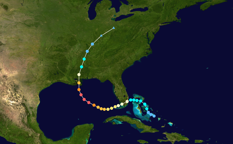
So guess what? It's not likely to happen, but will happen again! The above storms are all "cape verde" storms, that form off the coast of africa, and eventually hit the East coast and move into Ontario. Check out the route taken by Hurricane Fran:

Another type of storm pattern exists, and can produce fantastic rarities, but not in the same number or variety... One of the biggest in recent times was Hurricane Katrina, that brought Lesser Frigatebird, Gull-billed Tern, and Anhinga (to name a few) to Michigan waters on Lake Erie.. Check out that storms track here:
For the purpose of this post however, I'll focus on the "Carolina" hurricanes, since those are the most desirable. !!
----------
History lesson complete, lets look at how Hurricane forecasters make their early season predictions... From what I've read, we are well into a "period of heightened activity" - meaning we are likely to have "above average" years for quite a while. This year, after last winters La nina has ended, looks pretty darn good for storm formation.
Last years La nina seemed to push storms out over the ocean, with essentially no landfalls anywhere in the USA. We remain in a "neutral" state, which is good for storms, since the opposite (El nino) typically has conditions that are very poor for storm formation and end up being slow years.
One popular item they take into account is "analog years" ... Forecasters look at past years that had similar weather patterns (to date) to 2011... Now this is all just stuff I've read online, but I was pretty shocked to see the "analog years" for 2011... Take a look:
1955
1996
2008
Yes, you read that right, those years listed above had the most similar global weather patterns to 2011... Out of all the years they've been keeping records, the years MOST similar to this year, includes 1955 and 1996!! (the two biggest bird-storms in Ontario birding history)... What are the odds of that??
Now please keep in mind I don't really know what the heck i'm talking about with this weather stuff, but my understanding is the weakening la nina has a habit of shifting the "bermuda high" into a sweet spot in the Atlantic, which may help curve storms up the east coast and into the general area of the Carolinas.
And if that isn't enough, the global weather patterns since that prediction has been made, did not follow 2008 at all. In 2008, we developed into a strong La nina, which dumped rain on us every freakin day for most of the summer... If you remember back, it actually rained virtually EVERY day in July... Kinda different to this year eh?

(Hurricane Isabel, 2003)
So being armed with the knowledge of how rare these storms are (25/30 years per storm)... You should understand that we can never really expect it to happen.. BUT,,, but... if there was a year to have higher hopes than others,,, this may be it...

 by wxman57 » Fri Apr 08, 2011 10:30 am
Yes, that 1995 should read 1955 (fixed it). Analog years aren't "the law" as far as paths for 2011. They just suggest patterns that might be observed as far as development and movement. There are so many variables involved in determining where a hurricane eventually makes landfall. A small pocket of shear that develops in the mid Atlantic east of the Caribbean may delay development of a disturbance for a day. That delay in development might mean the difference in a Florida or East U.S. Coast hit or a Bermuda hit. Timing is everything. No one is safe from a possible impact because of any pattern indicated by analog years.
--------
Here's the path for Hurricane Connie in 1955, just to finish this up:

Keep an eye on those Hurricane Paths!!!
I know I will be! And there will be more here on the blog.

Oh how we need a storm... Pennsylvania has inland records after Hurricane Hazel in 1954! It's very possible under the right conditions.
I got the Michigan Anhinga at Holiday Beach
ReplyDeletePure luck. Other species I missed along the
shoreline there were Vermilion Flycatcher ( by
half an hour ), Saye's Phoebe ( Amhertsburg
Quarrie by half an hour ), and another bird.
I've also seen Avocets from the tower. Great
spot for fall birding.
Fred Urie
Interesting stuff.
ReplyDeleteHere's to hoping for some storm birds this fall! I've never done much "hurricane" birding!
In July this year, a dome of high pressure set
ReplyDeleteup over the eastern U.S. driving the lows up
and over the James Bay. If the July pattern
continued the hurricanes wouldn't penetrate
inland if they came up the coast.
Fred
Jeff Masters:
ReplyDelete" Today's extreme heat index values over the mid-Altantic are due, in large part, to near record warm ocean temperatures off the mid-Atlantic coast. According to the UK's HADSST2 data set, sea surface temperatures between 35° - 40°N and 75 ° - 70°W, along the coast from North Carolina to New Jersey, were 5.4°F (3.0°C) above average during June 2011. This is the warmest such temperature difference for any month in the historical record, going back to the 1800s. The most recent sea surface temperature anomaly maps from NOAA show that the July ocean temperatures have not been quite as extreme, but ocean temperatures in this region during July have averaged nearly 2°C above average, the second highest July ocean temperatures on record, behind 2010."
Interesting post Brandon - can't wait for the fall!
ReplyDeleteWe don't want any hurricane activity until AFTER the last week in August ... otherwise Brandon will be very sad LOL.
ReplyDeleteQuote : Alan said...
ReplyDeleteWe don't want any hurricane activity until AFTER the last week in August ... otherwise Brandon will be very sad LOL.
---
I've done some looking, and it seems like the average is 12 to 13 days from tropical storm formation, to landfall and dissipation in Ontario!
So if one were to go away (for say 12/13 days or so) then you would hopefully either have a good idea if you needed to cancel the trip before you left... Or arrive home before anything major happened!!!