Friday, February 28, 2014

Hanging by a wire


One of the stranger things I've seen in my years as a birder/consultant - a Horned Lark hanging dead from a hydro wire.


It was there for multiple weeks - hanging the same way... I would guess that a predator brought it there, and it somehow got stuck (or froze?) there... Pretty odd... Any ideas? 


(better times)


Thursday, February 27, 2014

Ice Cover


Ice on Feb 24th (above) - the big winds of our last storm did a decent job of hacking some holes in the Great Lakes Ice cover.


We have some freezing cold temps lined up for the next 10+ days - but every day has also been associated with a lot of strong winds - which don't bode well for ice formation on Lakes Michigan and Ontario.... The other three have so much ice cover though, that they could all freeze up again. 

Recent maps show that to be happening already - 


The strong winds of the last storm pushed a bunch of ice NE on Lake Erie - giving cause for the first designation of "very thick ice" so far in 2014... Not only that, but it seems to be covering at least half of the Lake! 


These guys seem to be taking a beating at the hands of this poor weather. I'm going out on a limb again and say that they still aren't being "frozen out" - and are instead migrating... I think it would explain the lack of body fat. (eg,/ migration uses up their fat stores - then they can't replenish them because they can't find good places to feed with all the ice around). Still - just my 2 cents. 


Wednesday, February 26, 2014

A day or two late


Updated 02/25/2014 @ 12:00 UTC
Major X4.9 Solar Flare
A major solar flare measuring X4.9 was just observed around returning sunspot 1967 (newly numbered 1990) at 00:49 UTC. Despite appearing to be in an advanced state of decay, the active region remains magnetically potent. This just proves that you cannot judge a book by its cover. A 10cm radio bust measuring 3700 sfu and lasting 85 minutes was associated with the event. The sunspot is not yet in a good geoeffective position for Earth directed eruptions. The flare is the 3rd largest X-Ray event of the current solar cycle. More updates to follow regarding a possible CME.


CME Update: Attached image below by LASCO C2 captures a halo coronal mass ejection (CME) leaving the sun at a quick rate of speed following the X4.9 flare event Monday night. Click HERE for a movie. Because the source sunspot (1990, ex 1967) is still located near the east limb, the plasma cloud is directed mostly away from Earth. Despite this, there does appear to be an Earth directed component which could deliver a glancing blow to our geomagnetic field by mid week. More updates to follow in the days ahead.
ALERT: Type II Radio Emission
Begin Time: 2014 Feb 25 0045 UTC
Estimated Velocity: 1972 km/s
Description: Type II emissions occur in association with eruptions on the sun and typically indicate a coronal mass ejection is associated with a flare event.
SUMMARY: 10cm Radio Burst
Begin Time: 2014 Feb 25 0042 UTC
Maximum Time: 2014 Feb 25 0045 UTC
End Time: 2014 Feb 25 0107 UTC
Duration: 85 minutes
Peak Flux: 3700 sfu
Description: A 10cm radio burst indicates that the electromagnetic burst associated with a solar flare at the 10cm wavelength was double or greater than the initial 10cm radio background. This can be indicative of significant radio noise in association with a solar flare. This noise is generally short-lived but can cause interference for sensitive receivers including radar, GPS, and satellite communications.


Doesn't that sound freakin awesome?!?! 


Tuesday, February 25, 2014

Why are lifetime memberships so freakin expensive?


A little rant post... Not much of a rant though... Facts, and a tiny bit of rant.


Looking at OFO memberships recently, I noticed that the annual rate is $35/year... Not bad, given the publications. 

Then I noticed they offer two and three year memberships, at exactly the same price (70 and 105)... I guess it saves you the tiny hassle of renewing for a few years, but other than that... 

Then I looked at the lifetime membership - SEVEN HUNDRED FREAKIN DOLLARS... 

That's TWENTY YEARS of membership fees before you begin to break even. Twenty years ago I was in grade 1 !!! How do I even know if OFO will be around in twenty years? 

I sort of get it, because the money needs to come from somewhere for OFO news, the website, Ontario birds (publishing AND mailing). But to be honest, beyond that, the website doesn't really do a great job of selling me. 

(Members enjoy - the Ontario Bird Records Committee - hahahaha... No one enjoys the OBRC... They - at best - tolerate it) ;) 


Next up - my hometown group - the Hamilton Naturalists Club!


$45/year !??!?! What the heck! That's $10 more than OFO - and I don't see any colour journals being published. 

In fact, I don't see anything on that page (at all) about what my benefits are as a member.. In classic "Ontario Nature" style - they just offer up more ways to give away your money. 

Lifetime membership - Seven hundred and fifty freakin bucks?!?! That's $50 more than OFO! Although it will "break even" in under 17 years, unlike the 20 years it takes for OFO... Although given that my only (usual) use of being an HNC member (in the past) has been reading the Wood Duck newsletter - that seems like a LOT of freakin money for newsletters...


What's your take on these memberships? I personally would have to see these groups cease to exist, as I think they're important in bringing the youth into birding/nature (they helped me) - but I'm still having a hard time trying to justify the funds for a few newsletters... 

What say you?! 


Monday, February 24, 2014

suckaassss


You thought spring was here, did ya?


That's right... Two solid weeks of below average temps... And not just "below average" - we're talking arctic air!!! And when I say arctic air, I mean - 


It's gonna be COLD!!!!!!!!!!!!!!

-----------

I have no idea who is scheduled to be at Grimsby (Beamer) for the start of the hawkwatch this spring - but the first few days of March are going to be extremely cold... If anyone actually stands out there for the entire day, they deserve to have a Gyrfalcon land on their face. 


Sunday, February 23, 2014

BC Birds - Stanley Park commoners


I took a 1.5 day layover in Vancouver back in December so I could get some Chestnut-backed Chickadee photos... The lil buggers turned out to be really tough to photograph, and I ended up with some mediocre results.


On the other hand, this Hairy Woodpecker photo was one I was reallly happy with!


Saturday, February 22, 2014

Glaucous-winged Gull photos from BC


Haven't done much photo editing this winter... OBRC stuff gets in the way I tell ya!


http://peregrineprints.com/zz_GWGU.htm


Even in Prince Rupert, the majority were "impure" like this bird... But were they hybrids with Western? Or Herring? Or are they just more variable than people give them credit for? 


Friday, February 21, 2014

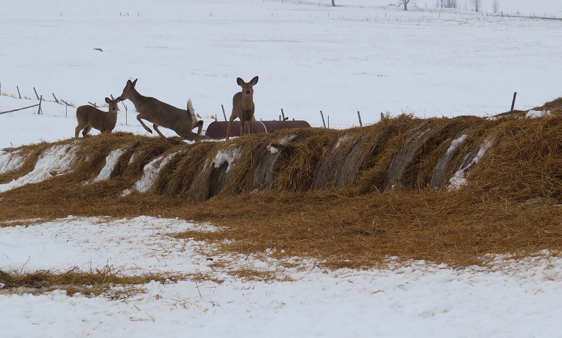
Deer in trouble


White-tailed Deer recently frozen out of Lake Ontario - crash landing on any available food source.


Hopefully this storm (and strong winds) will break up a lot of the ice cover on Lake Ontario to help them return to a normal lifestyle. 


(All jokes aside, this storm should break up some ice? I would think? Before it freezes again next week?) 


-----


ebird says there was a KILLDEER near Long Point yesterday! Makes me wonder - is it a true migrant, or an "overshoot" (or "vagrant"?) - either way, it's going to be cold next week!


Thursday, February 20, 2014

Very exciting weather! Over the next week!


A solid disclaimer for this post (and all my other posts)... "Model Runs" are NOT FORECASTS...


High res run of the NAM Model for this Thursday/Friday storm (Friday morning look)... This thing is a monster! Although I would call it a perfect "fall" storm - it sure isn't "fall"... 


Still calling for a 976mb monster.... I'm excited to see what the effects are on our birdlife. It's the WORST time of year (or nearly so) - but the storm is awesome...


Looking at the winds (GFS model run here)... Winds from Missouri hitting Lake Erie... A check of ebird shows that there isn't much happening in Missouri right now... Some notable birds - Snow, Ross's and Greater White-fronted Geese... Pintail, Shovellers etc... White Pelicans? If I were to pick a "mega" vagrant, I'd have to go with Great-tailed Grackle - but that's super unlikely 

Maybe that's why we don't really see vagrants this time of year... One's I would target are Slaty-backed Gull or Tufted Duck (if I had the "vagrant finding itch" right now, which I don't, really)... 


==============


Another friendly reminder - it's going to be COLD COLD COLD after this little storm moves away :) 

==============


Here are the warnings (4pm on Feb 19th) for our upcoming storm... Nothing to do with birds, but this could get messy with LOTS of rain and LOTS of melting snow all at once...


City of Hamilton
3:59 PM EST Wednesday 19 February 2014
Rainfall warning for 
City of Hamilton continued


Major storm bringing 25 - 50 mm of rain Thursday and Friday.

An Alberta clipper and Texas low will be tracking towards the Great Lakes where they will merge and rapidly intensify. This storm system will bring rising temperatures to Southern Ontario along with significant precipitation and strong winds.

Rain is expected to begin over Southwestern Ontario near midday Thursday then spread eastward to the Golden Horseshoe Thursday afternoon reaching the Kingston area early Thursday evening. There is a chance that a brief period of snow, freezing rain or ice pellets may precede the rain as temperatures rise from just below freezing to above.

Total rainfall amounts of 25 to 50 mm are expected over the warned areas, with the highest amounts forecast to be in the Windsor-Sarnia to Hamilton-Niagara corridor. In addition, thunderstorms will be possible over Southwestern Ontario and the Golden Horseshoe, and may result in locally higher rainfall amounts. Significant snow melt due to the rising temperatures will also be a concern.

As the rain comes to an end from west to east Friday, winds will increase out of the southwest with gusts to 70 or 80 km/h possible, particularly along the great lake shores.

Meteorologists continue to monitor the development of these weather systems.

Please monitor the latest forecasts and warnings from Environment Canada at www.weatheroffice.gc.ca.


Snowfall warnings, winter storm watches, and special weather statements for northern Ontario.... Every part of Ontario has some type of statement-warning from this system. Woot!

Check here for more details: http://weather.gc.ca/warnings/index_e.html


Wednesday, February 19, 2014

Monster weather event on our hands???


Things are looking very interesting for Thursday-Friday on the olde' weather charts...


Thursday morning - decent 994mb lows (Colorado low?) and 998 Low (Alberta Clipper like thing?) moving towards southern Ontario...


Friday -

Phasing of the jet stream (and the two lows) into a 976mb utter monstrosity over Lake Superior!!!


Storm Prediction Centre of NOAA forecasting a big chance for severe weather due to this event in the USA - most likely from strong winds - and maybe a few Tornadoes!


GFS:


The timing may be off for us to get any diurnal migrants on Friday for southern Ontario... But maybe warm winds overnight will bring some migrants?

Thursday could have a few as well, but I'm not realllly hopeful at this point... 

Overall though it looks pretty exciting (for February standards), so I'll be keeping my eyes peeled on ebird and other locations to see what types of birds may move around during this event. This is probably the first true "spring like" storm of 2014 for our area. 


GFS run (12z on Feb 18) - showing temps of +5C for most of southern Ontario - at 2AM(!!!) on Friday 


===============


Looking ahead - 

Next week shows a return of the freeeezing cold weather early in the week, then the chance for some UBER cold late next week - but its a lonnng ways away to know for sure


GFS hinting at some VERY cold air for southern Ontario...


Muwahahahahhaa


Monday, February 17, 2014

Con-do! Bir-ding! Up-date! Feb 4 to Feb 17th!


(all photos in this post are from the patch, during this time frame!) 


Oh ya, it's a "condo birding update" .... The synopsis - I've hardly been "birding" from the condo. This time of year stinks... And I'm talkin "lack of good birds stink"...

With that said, I've still had some random sightings of great birds! Things are picking up!


February 4 - SNOWY OWL!!!!!!!!!!!!!! New condo bird... Finally had one on a chunk of ice, waay offshore... I saw it take a bath! How cool is that? (It was really distant, but I didn't really care)...

Also had a Red-necked Grebe swimming offshore mid afternoon... Clearly starving after being "frozen out" from Hudson Bay last week...


Feburary 5th - Red-throated Loon !!! - a strong NE wind, but few birds. The loon was up high and moving west.. Clearly "frozen out" from Lake Ontario, given that Lake Ontario hasn't frozen over for years...


February 8th - Canvasback! A beauty male just offshore with the geese in the morning...


February 10th - ICE! Ice all the way to the horizon...


Some really sweet ice! 


February 13th - still lots of ice!!! A notable increase in gulls this day, and I was really surprised to see an adult LESSER Black-backed Gull... Migration underway with gulls as well, I think!

Other good birds were 2 Iceland Gulls, 1 Glaucous Gull, and 1 beauty American Robin on the front lawn of my building when I drove in... (A small group have wintered locally).


February 16th - SNOWY OWL!!! Ice conditions were excellent, with a great mix of solid stuff, and open water - keeping all manner of birds happy. The young male Snowy flew east mid day...

Other good birds were a "patch" Northern Shrike, another Robin, and a flyby Glaucous Gull... In the evening, I had another great highlight in the form of ---- another SNOWY OWL baby!!! A probable "adult" male, giving chase (poorly) to some big flocks of ducks waaay out - as the sun was setting.


February 17th - SNOWY OWL!!! A young female on the ice at dawn... 3rd bird in 24 hours. Flew around a little bit, but stayed perched for the first 3-4 hours of the day, floating on a small piece of ice, surrounded by floating slush...


(the female)


This day was pretty active. A short walk around the patch had more Robins, a/the Shrike, 1 American Kestrel, and a patch FIRST --- NORTHERN MOCKINGBIRD!!! #189 ...


Another big highlight of the day was the gulls... Good ice for roosting, combined with an afternoon east wind, meant I had some very solid totals... No major highlights but I ended up with FOURTEEN Glaucous and SEVEN Iceland among the regulars! Ring-bill's are increasing as well...


Glaucous on far left, Iceland on far right. 

Things are lookin up!