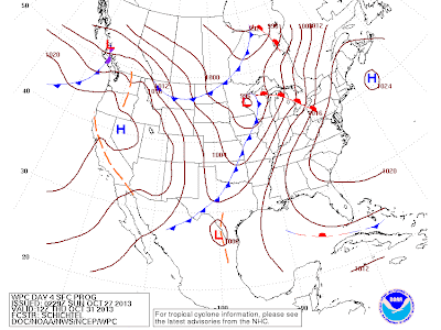
Forecast for tonight (Sunday to Monday)
Surface map from the evening of Nov 5, 2009 (the following day had an Ash-throated + Sulphur-bellied Flycatcher found in southern Ontario).
ANYONE notice any similarities between those two maps?! Anyone?! Anyone?!
What's going to happen? (it looks boring as heck, but history shows it wasn't).
Another similarity is that in 2009, this was a precursor to a "warm air event" into the southern part of the province.... Here's another forecast map:
Map for this Thursday... Crazy lookin!
One problem I could forsee is that the "warm air" could bring a lot of rain to southern Ontario (well, I know it will) - which may stop the lil-birdies from reaching us? (if any move north, that is).
Although that won't be a problem if the above map verifies (Nov 1st) - where the "back side" of the storm wraps around into southern Ontario... Note the low has bombed out to a 978mb monster. I think this is because there will be some phasing of the polar and subtropical jet - with the polar jet grabbing the low earlier than expected. Kinda has me a little less excited about the storm now, but I'll still wait and watch for what gets reported! (and maybe go looking a bit myself).
------------------------------
------------------------------
------------------------------
This day in 2012: SANDY
A post I did to HamiltonBirds on this day:
The approach of Hurricane Sandy (a hybrid storm, also going by the name Frankenstorm, due to its expected impacts around Halloween) is now of great interest to birders in Ontario. The exact track the storm, which is very difficult to predict at this time, will likely determine the birds that could be displaced by the system. To start, winds should increase from the north to northeast as the system approaches. Birders in Ohio this morning reported record numbers of grounded waterfowl such as Scoters, Harlequin Ducks, Brant and even a probable Common Eider. By Monday evening, winds in Hamilton could be approaching 100kmh from the NE - which should either make the birding very exciting or extremely difficult....
I don't like to predict much more than that for now, but I will be updating my blog on the situation when possible over the next few days... Care for extensive rain, flash flooding, fallen trees and power outages should also be taken into account...
Happy birding!
Brandon
I don't like to predict much more than that for now, but I will be updating my blog on the situation when possible over the next few days... Care for extensive rain, flash flooding, fallen trees and power outages should also be taken into account...
Happy birding!
Brandon
------------------------------
This was also the first day I made predictions on the "phases of sandy" public
===================================================
I'm going to bet that Josh V gets a Fulmar or two tomorrow (Oct 28th) on James Bay - likely their best "wind" day of their first week (if not the entire trip, unless they luck out again around Nov 2-3-4th
WindsIssued 05:00 AM CDT 27 October 2013
Today Tonight and Monday
Gale warning in effect.
Wind light increasing to west 15 knots late this morning and to west 20 early this afternoon. Wind veering to northwest 15 late this afternoon then increasing to northwest 25 late this evening. Wind increasing to northwest 35 late overnight then diminishing to northwest 30 Monday afternoon.


Anticipation...............!
ReplyDeleteI hear ya! Hopefully it's worth the hype... I have a sneaky suspicion that things are picking up as of today... Hopefully we're in for a good blast over the next 10-14 days!
Delete