
WOW... I don't care what you think about global warming/climate change, but there is NO way you can dispute the fact that the last 3-5 years have been a non-stop roller coaster ride of insane weather events.
Here's a statement from the US National Weather Service in Buffalo, NY:
IN TERMS OF HOW POTENTIALLY UNUSUAL THIS WHOLE EVENT COULD BE (ESP
THE SNOW ASPECT OF IT)...NEARLY ALL OF THE MAJOR FORECAST PARAMETERS (500MB AND 700MB HEIGHTS...MSLP...850MB TEMPS...AND WIND COMPONENTS) ARE 4 TO 5 STANDARD DEVIATIONS FROM NORMAL. IT IS CERTAINLY SIGNIFICANT WHEN A COUPLE FORECAST PARAMETERS ARE THAT ANOMALOUS...
BUT WHEN NEARLY ALL OF THE MAIN FACTORS ARE THIS FAR FROM
NORMAL...THEN THE EVENT STARTS TO RISE TO THAT OF A MEMORABLE OR
EVEN HISTORIC STATURE...IF ALL OF THESE FACTORS REMAIN IN PERFECT
ALIGNMENT.
NWS Buffalo NY
==================================
So, what's going down??

Early Sunday: Low pressure over Florida, fairly strong at 1000mb (100.0kpa)

Mid day Sunday: moves to the coast/offshore and goes north.. Still at 1000mb
 \
\
Early Monday (12am) : the beast is still offshore, centre of Low near New Jersey... Intensifies to 994mb
Early Tuesday (12am): gets even more powerful to 988mb and pulls into Ontario?! To put that in perspective, a category 1 hurricane is usually in the 994 to 980 range.. This storm isn't tropical in nature, but it IS that strong.....
============
The CENTRE of the low is often a prime location for vagrants, but this is a fairly rare type of setup for the spring, so I have no idea how it would pan out... It would be great if we could convince every birder from Presqu'ile eastwards to bird the heck out of the area from Monday-Thursday and see if they find anything... But unfortunately I'm not volunteering to try...
Seems very promising though, considering it is right close to the coast the whole way (and only 48ish hours removed from being in Florida!)
We'll have to watch and wait... Ottawa should get a direct hit, so hopefully the numerous birders can find something there if it pans out...
-------------
In the meantime, west of that area (Hamilton?) will be enjoying some snow :)

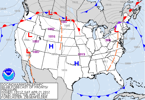
Here's a weather map for Monday, showing our chances at some heavy snow :)
Some models are saying as much as 8-12 inches for the Toronto/Hamilton area, although I'm thinking the heat in the Great Lakes should keep us in the rain and only get a wet cm or two... South of the Great Lakes could see several inches though!
==================
Unfortunately, it's sort of like being hit by the wrong side of the Hurricane for most of southern Ontario, but I don't think it will be a total waste... We've had remarkable run of heat and vagrants so far... And I have a theory that places like Point Pelee actually get a healthy dose of vagrants on NORTH winds as they "migrate south" in the spring after overshooting...
Sort of makes sense when you think about it... Pelee is a huge funnel for fall migrants, so why not spring vagrants going south? Same goes for Long Point etc...
And if north winds DO actually produce vagrants for Pelee, there will be no shortage of them over the next 7 days. Here's the wind forecast:
| NE 35 km/h | N 70 km/h | NW 40 km/h | N 15 km/h | N 30 km/h |
Sunday Monday Tuesday Wednesday Thursday
The north 70kmh on Monday is pretty freaky... I wonder if there are any White-throated Swifts/White-tailed Kites that are floating around Ontario right now that are going to have to flee this cold weather?
Heck, I'd settle for something like a White-faced Ibis/Ferruginous Hawk/Swallow-tailed Kite/Violet-green Swallow... Although given the austral migrant invasion of the great lakes, how about a White-collared Swift? Any takers?
I'm pretty tempted to go down and look, and I'm sure something good could happen considering the power a Josh Vandermulen big year can have on major increases in Ontario rarities...

========
On an un-related note, I'm going to post a picture of the Wheatley Harbour Slaty-backed Gull every day until I get a rise out of someone:

This weather is mind-boggling. Even since last fall!
ReplyDelete